IMAGES TAKEN NEAR TO
Ryehill Close, NOTTINGHAM, NG2 3LG
Introduction
This page details the photographs taken nearby to Ryehill Close, NG2 3LG by members of the Geograph project.
The Geograph project started in 2005 with the aim of publishing, organising and preserving representative images for every square kilometre of Great Britain, Ireland and the Isle of Man.

There are currently over 7.5m images from over14,400 individuals and you can help contribute to the project by visiting https://www.geograph.org.uk
Image Map
Images are licensed for reuse under creativecommons.org/licenses/by-sa/2.0
Notes
- Clicking on the map will re-center to the selected point.
- The higher the marker number, the further away the image location is from the centre of the postcode.
Image Listing (261 Images Found)
Images are licensed for reuse under creativecommons.org/licenses/by-sa/2.0
Image
Details
Distance
1
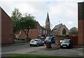
The Meadows: St Saviour's Church and St Saviour's Gardens
These houses and a new road layout replaced straight streets of Victorian terraced houses in the 1970s.
Image: © John Sutton
Taken: 29 Apr 2013
0.04 miles
2
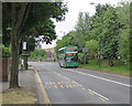
Meadows Way: Eugene Gardens bus stop
A Nottingham City Transport 10X service to Rushcliffe Country Park has just set off towards Trent Bridge from the southbound Eugene Gardens stop. The city-bound stop is on the left. Meadows Way replaced Arkwright Street as the bus route when The Meadows area was redeveloped in the late 1970s. (True Nottinghamian pronunciation is "Medders".)
Image: © John Sutton
Taken: 27 Jun 2017
0.04 miles
3
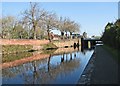
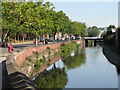
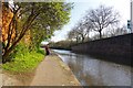
A May morning by the Nottingham Canal
Looking towards Cattle Market Road Bridge and the city centre.
Image: © John Sutton
Taken: 3 May 2016
0.05 miles
4
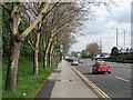
London Road: looking north
Traffic making its way into the city on a cloudy May morning.
Image: © John Sutton
Taken: 9 May 2012
0.05 miles
5
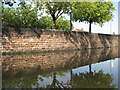
Nottingham Canal: retaining wall and reflections
The stone retaining wall on the London Road side of the canal, seen from the towpath on a mild September morning.
Image: © John Sutton
Taken: 15 Sep 2011
0.05 miles
6
Nottingham Canal: anglers
Tranquillity ten yards from the traffic on London Road.
Image: © John Sutton
Taken: 23 Jul 2008
0.06 miles
7
London Road: April hailstorm
The downpour which had ended play for the day at Trent Bridge Cricket Ground turned briefly into a hailstorm. Bridge 1a, in the middle distance, carries Cattle Market Road over the Nottingham Canal.
Image: © John Sutton
Taken: 20 Apr 2012
0.06 miles
8
London Road and the Nottingham Canal
Looking north towards the city on a bright August morning. The bridge carrying Cattle Market Road is in the middle distance, the towpath walk on the right.
Image: © John Sutton
Taken: 24 Aug 2011
0.06 miles
9
A quiet Canal
Not much activity on the Image on this Saturday afternoon
Image: © Glyn Baker
Taken: 18 Apr 2015
0.07 miles
10
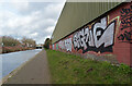
Graffiti alongside The Nottingham Canal, Nottingham
Image: © habiloid
Taken: 17 Feb 2023
0.07 miles