IMAGES TAKEN NEAR TO
Brand Street, NOTTINGHAM, NG2 3GW
Introduction
This page details the photographs taken nearby to Brand Street, NG2 3GW by members of the Geograph project.
The Geograph project started in 2005 with the aim of publishing, organising and preserving representative images for every square kilometre of Great Britain, Ireland and the Isle of Man.

There are currently over 7.5m images from over14,400 individuals and you can help contribute to the project by visiting https://www.geograph.org.uk
Image Map
Images are licensed for reuse under creativecommons.org/licenses/by-sa/2.0
Notes
- Clicking on the map will re-center to the selected point.
- The higher the marker number, the further away the image location is from the centre of the postcode.
Image Listing (149 Images Found)
Images are licensed for reuse under creativecommons.org/licenses/by-sa/2.0
Image
Details
Distance
1
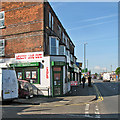
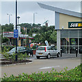
Sneinton: Meadow Lane Cafe
The corner of Brand Street, looking along Meadow Lane towards Lady Bay Bridge, London Road and Trent Bridge.
Image: © John Sutton
Taken: 16 May 2016
0.02 miles
2
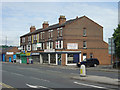
Shops on Meadow Lane
There was formerly more residential accommodation in the area, but it is now entirely industrial/commercial. The shops are now mainly small specialist retail. The pillar box has the remains of a Post Office sign on top, and clearly the (now closed) newsagent was originally the local Post Office.
Image: © Alan Murray-Rust
Taken: 29 May 2008
0.03 miles
3
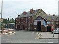
Sneinton: Brand Street
One of several streets of industrial units south of Meadow Lane.
Image: © John Sutton
Taken: 16 May 2016
0.04 miles
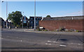
4
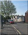
Moreland Street
This small group of terraced houses is out of place in an otherwise industrial area, but they appear not to have been used as dwellings for some time.
Image: © Alan Murray-Rust
Taken: 29 May 2008
0.06 miles
5
Fast food and turning sails
A view from Meadow Lane towards Green's Mill in Sneinton, whose sails were turning on a drab Sunday morning in what passed for midsummer.
Image: © John Sutton
Taken: 23 Jun 2013
0.07 miles
6
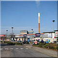
Sneinton: Lady Bay Retail Park
The Eastcroft Incinerator is in the background.
Image: © John Sutton
Taken: 13 Apr 2016
0.08 miles
8
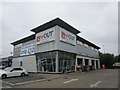
In'n'Out motor services
Bane Lane Retail Park.
Image: © Jonathan Thacker
Taken: 9 Jul 2018
0.10 miles
9
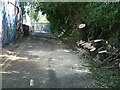
Lady Bay Bridge closure, July 2022 ? 5
On 4 July 2022 an 8-wheel waste skip lorry ran out of control while crossing the bridge northbound and ended by crashing through the parapet on the eastern side, adjacent to Meadow Grove. The driver suffered significant but not life threatening injuries. The main structure of the bridge was not affected but the bridge was closed to traffic pending introduction of a one-way system. At the time I took this picture, the concrete barriers to enable this had been put in place, but the bridge remained closed to vehicular traffic. Cycle and pedestrian traffic is not affected as these use a dedicated foot and cycleway on the western side of the bridge, with the option of also using the main carriageway whilst this was closed to vehicles. This in itself provided the opportunity for some different views of and from the bridge. This view shows the access road to the storage area where the lorry landed https://www.geograph.org.uk/photo/7223147 , where a tree clearly had to be removed to allow access for emergency and recovery vehicles.
Image: © Alan Murray-Rust
Taken: 9 Jul 2022
0.11 miles
10
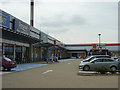
Lady Bay Retail Park
Modern retail redevelopment on a former engineering works site.
Image: © Alan Murray-Rust
Taken: 29 May 2008
0.11 miles