IMAGES TAKEN NEAR TO
Freeth Street, NOTTINGHAM, NG2 3GT
Introduction
This page details the photographs taken nearby to Freeth Street, NG2 3GT by members of the Geograph project.
The Geograph project started in 2005 with the aim of publishing, organising and preserving representative images for every square kilometre of Great Britain, Ireland and the Isle of Man.

There are currently over 7.5m images from over14,400 individuals and you can help contribute to the project by visiting https://www.geograph.org.uk
Image Map
Images are licensed for reuse under creativecommons.org/licenses/by-sa/2.0
Notes
- Clicking on the map will re-center to the selected point.
- The higher the marker number, the further away the image location is from the centre of the postcode.
Image Listing (176 Images Found)
Images are licensed for reuse under creativecommons.org/licenses/by-sa/2.0
Image
Details
Distance
1

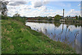
An April evening by the Trent
The tall chimney is at the Eastcroft incinerator. There had been heavy rain late in the afternoon.
Image: © John Sutton
Taken: 7 Apr 2014
0.03 miles
2

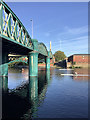
Crossing the Trent at Lady Bay Bridge
A view against strong early-morning light, taken from the footway bracketed out from the west side of the bridge (originally a railway bridge and now a busy road approach to Nottingham from the east). In the distance to the right is one of the new residential blocks being built at Trent Basin.
Image: © John Sutton
Taken: 4 Jul 2016
0.04 miles
3
Approaching Lady Bay Bridge
The Trent Valley Way Long Distance Footpath follows the southern bank of the River Trent. The northern bank is dominated by old factories, warehouses and wharfs. Lady Bay Bridge is just visible round the bend in the river.
Image: © Kate Jewell
Taken: 1 May 2008
0.04 miles
4

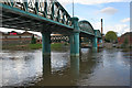
Cruising the Trent
View downstream through the girders of Lady Bay Bridge.
Image: © Alan Murray-Rust
Taken: 29 May 2008
0.04 miles
5
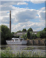
Across the Trent on a June afternoon
Just downstream from Lady Bay Bridge. Eastcroft Incinerator chimney is visible from miles away on this side of the city.
Image: © John Sutton
Taken: 3 Jun 2015
0.05 miles
6
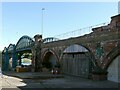
Lady Bay Bridge
Once a railway bridge this was converted to road traffic in the late 1970s to give a second crossing into the city.
Image: © Kate Jewell
Taken: 1 May 2008
0.06 miles
7
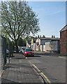
Sneinton: Brand Street
One of several streets of industrial units south of Meadow Lane.
Image: © John Sutton
Taken: 16 May 2016
0.06 miles
8
Lady Bay Bridge closure, July 2022 ? 6
On 4 July 2022 an 8-wheel waste skip lorry ran out of control while crossing the bridge northbound and ended by crashing through the parapet on the eastern side, adjacent to Meadow Grove. The driver suffered significant but not life threatening injuries. The main structure of the bridge was not affected but the bridge was closed to traffic pending introduction of a one-way system. At the time I took this picture, the concrete barriers to enable this had been put in place, but the bridge remained closed to vehicular traffic. Cycle and pedestrian traffic is not affected as these use a dedicated foot and cycleway on the western side of the bridge, with the option of also using the main carriageway whilst this was closed to vehicles. This in itself provided the opportunity for some different views of and from the bridge. This view shows the place where the lorry fell from the bridge after demolishing the parapet complete with its safety barriers.
Image: © Alan Murray-Rust
Taken: 9 Jul 2022
0.07 miles
9
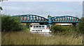
Scullers at Lady Bay Bridge
Now a road crossing, Lady Bay Bridge was built by the Midland Railway in 1878 to carry its main line from Nottingham to St Pancras via Melton Mowbray and Oakham. In railway days it was not this startling turquoise colour. The picture was taken on a bright September morning.
Image: © John Sutton
Taken: 17 Sep 2019
0.07 miles
10
Lady Bay Bridge
Whilst a heavy lorry thunders over the bridge the Nottingham Princess floats serenely by.
Image: © Oxymoron
Taken: 7 Aug 2008
0.07 miles