IMAGES TAKEN NEAR TO
Wallett Street, NOTTINGHAM, NG2 3EL
Introduction
This page details the photographs taken nearby to Wallett Street, NG2 3EL by members of the Geograph project.
The Geograph project started in 2005 with the aim of publishing, organising and preserving representative images for every square kilometre of Great Britain, Ireland and the Isle of Man.

There are currently over 7.5m images from over14,400 individuals and you can help contribute to the project by visiting https://www.geograph.org.uk
Image Map
Images are licensed for reuse under creativecommons.org/licenses/by-sa/2.0
Notes
- Clicking on the map will re-center to the selected point.
- The higher the marker number, the further away the image location is from the centre of the postcode.
Image Listing (678 Images Found)
Images are licensed for reuse under creativecommons.org/licenses/by-sa/2.0
Image
Details
Distance
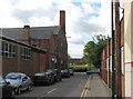
1
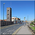
Along Crocus Street
The tower of the new Fire Station is on the left, on the corner of Wallet Street.
Image: © John Sutton
Taken: 26 May 2017
0.02 miles
2
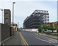
Changing Crocus Street
Steelwork for new flats has gone up on a site which has been vacant for a number of years. For comparison, see Image] (June 2015), Image] and Image] (both May 2017). The tower of the new Fire Station is on the left and a glimpse of the former Hicking Pentecost works (in Image) on the extreme right.
Image: © John Sutton
Taken: 13 May 2018
0.02 miles
3
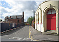
The corner of Wallet Street
A view from Crocus Street. The factory buildings to the left are being demolished. For an idea of what was here before the contractors moved in, see Image] (August 2010).
Image: © John Sutton
Taken: 1 Jun 2015
0.02 miles
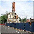
4
Wallet Street: building the new fire station
When this building is finished the city-centre fire station, on Shakespeare Street, will close.
Image: © John Sutton
Taken: 8 Jun 2016
0.02 miles
5
Wallet Street
The factory building is on the corner of Waterway Street, once a much longer cross-Meadows street which was truncated during the slum-clearance and redevelopment of the 1970s. Some of the houses which replaced the Victorian terraces are in the background.
Image: © John Sutton
Taken: 24 Aug 2010
0.03 miles
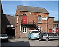
6

Wallet Street, Nottingham NG2
The rear of a factory unit on Wallet Street; premises that seem likely to disappear in 2015 when the new Fire & Rescue Services HQ is built between Wallet Street and Crocus Street? The entrance and exit for fire and rescue vehicles is expected to be on London Road.
Image: © David Hallam-Jones
Taken: 23 Aug 2014
0.03 miles
7
The remains of Gresham Works
The following day it had gone. Image] was taken from more or less the same spot four weeks before.
Image: © John Sutton
Taken: 29 Jun 2015
0.04 miles
8
Wallet Street: not much left
The chimney and gable end of the former Gresham Works had gone by the following day. Image] was taken from more or less the same spot a month earlier.
Image: © John Sutton
Taken: 29 Jun 2015
0.04 miles
9
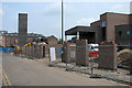
London Road: part of Gresham Works
A former factory which housed several businesses, it was demolished in 2015 - see Image
Image: © John Sutton
Taken: 22 Apr 2009
0.04 miles
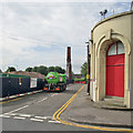
10
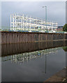
Steelwork reflected in the Nottingham Canal
The steel frame of the new Nottingham Fire Station rising on the site of the former Gresham Works, which was demolished earlier in the summer of 2015. There had been overnight rain, but the clouds cleared in mid morning and the rest of the day was sunny and warm.
Image: © John Sutton
Taken: 12 Sep 2015
0.04 miles