IMAGES TAKEN NEAR TO
Holme Lane, NEWARK, NG23 7RT
Introduction
This page details the photographs taken nearby to Holme Lane, NG23 7RT by members of the Geograph project.
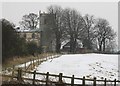
The Geograph project started in 2005 with the aim of publishing, organising and preserving representative images for every square kilometre of Great Britain, Ireland and the Isle of Man.

There are currently over 7.5m images from over14,400 individuals and you can help contribute to the project by visiting https://www.geograph.org.uk
Image Map
Images are licensed for reuse under creativecommons.org/licenses/by-sa/2.0
Notes
- Clicking on the map will re-center to the selected point.
- The higher the marker number, the further away the image location is from the centre of the postcode.
Image Listing (54 Images Found)
Images are licensed for reuse under creativecommons.org/licenses/by-sa/2.0
Image
Details
Distance
1
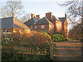
Langford Old Vicarage
Substantial Victorian house, now offering bed and breakfast.
http://www.langfordoldvicarage.co.uk/index.htm
Image: © Trevor Rickard
Taken: 29 Dec 2011
0.00 miles
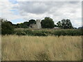
2
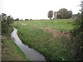
The Fleet and St. Bartholomew's, Langford
Image: © Jonathan Thacker
Taken: 24 Sep 2011
0.01 miles
3
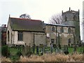
Church of St Bartholomew, Langford
For history - http://www.winthorpe.org.uk/langford-church
Image: © Tim Heaton
Taken: 11 Jan 2009
0.02 miles
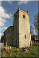
4
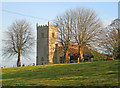
St Bartholomew's Church
Isolated church well north of Langford village. The church was built between 1190 and 1254 and replaced an earlier Saxon church. Further additions were made in the 14th and 15th centuries and a full restoration was carried out in 1862. Easier to view in the winter when the surrounding trees are bare.
http://www.winthorpe.org.uk/langford-church
Image: © Trevor Rickard
Taken: 29 Dec 2011
0.02 miles
5
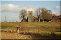
St.Bartholomew's church
View from Holme Lane at Langford
Image: © Richard Croft
Taken: 4 Feb 2013
0.02 miles
6
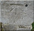
Ordnance Survey 1GL Bolt
This OS Bolt can be found on the west face of St Bartholomew's Church. It marks a point 13.000m above mean sea level.
Image: © Adrian Dust
Taken: 5 Jun 2016
0.02 miles
7
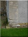
Cut Mark: Langford, St. Bartholomew's Church
One of two benchmarks on the tower of the church. See http://www.bench-marks.org.uk/bm25565 for details of this mark.
Image: © Brian Westlake
Taken: 20 Oct 2017
0.02 miles
8
St. Bartholomew's church, Langford
Overlooks the Lincoln to Newark and Nottingham railway line.
Image: © Jonathan Thacker
Taken: 28 Aug 2021
0.02 miles
9
St. Bartholomew's church
Grade 1 listed church with a 13th century tower, much altered as the village of Langford shrunk as the population declined.
Image: © Richard Croft
Taken: 12 Apr 2021
0.02 miles