IMAGES TAKEN NEAR TO
Langford, NEWARK, NG23 7RS
Introduction
This page details the photographs taken nearby to NG23 7RS by members of the Geograph project.
The Geograph project started in 2005 with the aim of publishing, organising and preserving representative images for every square kilometre of Great Britain, Ireland and the Isle of Man.

There are currently over 7.5m images from over14,400 individuals and you can help contribute to the project by visiting https://www.geograph.org.uk
Image Map
Images are licensed for reuse under creativecommons.org/licenses/by-sa/2.0
Notes
- Clicking on the map will re-center to the selected point.
- The higher the marker number, the further away the image location is from the centre of the postcode.
Image Listing (8 Images Found)
Images are licensed for reuse under creativecommons.org/licenses/by-sa/2.0
Image
Details
Distance
1
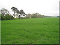
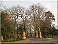
Langford Hall
New Langford Hall in the trees and Hall Farm down a muddy track from the A46
Langford Hall was built c1785 by John Carr of York for the Duncombe family
Image: © Richard Croft
Taken: 2 Mar 2010
0.03 miles
5
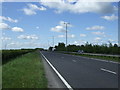
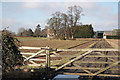
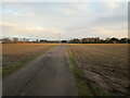
Hall Farm
Track from the A46 to Hall Farm at Langford
Image: © Richard Croft
Taken: 2 Mar 2010
0.20 miles