IMAGES TAKEN NEAR TO
Station Road, NEWARK, NG23 7RA
Introduction
This page details the photographs taken nearby to Station Road, NG23 7RA by members of the Geograph project.
The Geograph project started in 2005 with the aim of publishing, organising and preserving representative images for every square kilometre of Great Britain, Ireland and the Isle of Man.

There are currently over 7.5m images from over14,400 individuals and you can help contribute to the project by visiting https://www.geograph.org.uk
Image Map
Images are licensed for reuse under creativecommons.org/licenses/by-sa/2.0
Notes
- Clicking on the map will re-center to the selected point.
- The higher the marker number, the further away the image location is from the centre of the postcode.
Image Listing (73 Images Found)
Images are licensed for reuse under creativecommons.org/licenses/by-sa/2.0
Image
Details
Distance
1
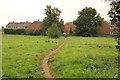
Footpath to The Paddock
Public footpath between Station Road and The Paddock at Dykes End
Image: © Richard Croft
Taken: 20 Sep 2014
0.12 miles
3

Collingham Co-op
Collingham Co-op … the third and largest Co-op store in Collingham in the last 25 years
Image: © Richard Croft
Taken: 18 Feb 2019
0.12 miles
4

Parking Space
Designated Mother & child parking space at Collingham Co-op http://www.geograph.org.uk/photo/6063780 seemingly visually representing the currently obese proportion of the general population.
Image: © Richard Croft
Taken: 18 Feb 2019
0.13 miles
6
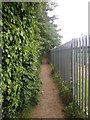
Footpath to Dykes End, Collingham
Passes an ash tree almost totally covered in ivy.
Image: © Jonathan Thacker
Taken: 15 Dec 2019
0.16 miles
7

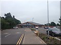
Collingham Centre
This is the Co Op Store, medical centre and Library in the centre of the village.
Image: © roger geach
Taken: 15 Jan 2011
0.17 miles
9
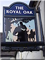
Sign for the Royal Oak
Royal Oak is one of the most common pub names and is found throughout the country, and it primarily refers to an actual historical event. The celebrated historical event was the escape of Charles II after his army was defeated at Worcester in 1651, when he climbed into an oak tree at Boscobel to hide from the Parliamentary soldiers.
It also refers to one or other of the various Royal Naval warships that bear the name, and there is also a link to folklore too, since May 29th was celebrated as Royal Oak Day from 1661 until late into the 19th century.
Image: © Maigheach-gheal
Taken: 2 Apr 2011
0.19 miles
10
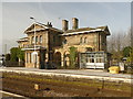
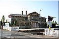
Collingham railway station
The northbound platform with the well preserved station building behind.
Image: © Graham Hogg
Taken: 29 Feb 2016
0.20 miles