IMAGES TAKEN NEAR TO
Wheatley Lane, NEWARK, NG23 7QG
Introduction
This page details the photographs taken nearby to Wheatley Lane, NG23 7QG by members of the Geograph project.
The Geograph project started in 2005 with the aim of publishing, organising and preserving representative images for every square kilometre of Great Britain, Ireland and the Isle of Man.

There are currently over 7.5m images from over14,400 individuals and you can help contribute to the project by visiting https://www.geograph.org.uk
Image Map
Images are licensed for reuse under creativecommons.org/licenses/by-sa/2.0
Notes
- Clicking on the map will re-center to the selected point.
- The higher the marker number, the further away the image location is from the centre of the postcode.
Image Listing (8 Images Found)
Images are licensed for reuse under creativecommons.org/licenses/by-sa/2.0
Image
Details
Distance
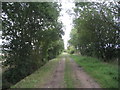
1
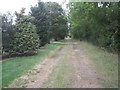
South Scaffold Lane
The garden of Wheatley Grange on the left.
Image: © Jonathan Thacker
Taken: 29 Aug 2011
0.09 miles
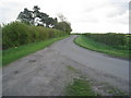

5
The end of Wheatley Lane
At the gate of Wheatley Grange the track turns right and becomes South Scaffold Lane.
Image: © Jonathan Thacker
Taken: 2 Jan 2021
0.16 miles
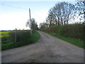
6
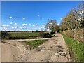
Bridleway and Lane Junction near Wheatley Farm
Image: © Jonathan Clitheroe
Taken: 30 Mar 2024
0.16 miles
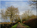
8
South Scaffold Lane
Near Wheatley Farm.
Image: © Jonathan Thacker
Taken: 29 Aug 2011
0.20 miles