IMAGES TAKEN NEAR TO
Stapleford Lane, NEWARK, NG23 7QD
Introduction
This page details the photographs taken nearby to Stapleford Lane, NG23 7QD by members of the Geograph project.
The Geograph project started in 2005 with the aim of publishing, organising and preserving representative images for every square kilometre of Great Britain, Ireland and the Isle of Man.

There are currently over 7.5m images from over14,400 individuals and you can help contribute to the project by visiting https://www.geograph.org.uk
Image Map
Images are licensed for reuse under creativecommons.org/licenses/by-sa/2.0
Notes
- Clicking on the map will re-center to the selected point.
- The higher the marker number, the further away the image location is from the centre of the postcode.
Image Listing (8 Images Found)
Images are licensed for reuse under creativecommons.org/licenses/by-sa/2.0
Image
Details
Distance
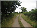
1
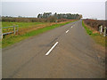
Stapleford Lane
Heading north-west across flat arable farmland towards Brough.
Image: © Trevor Rickard
Taken: 23 Dec 2011
0.09 miles
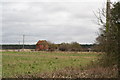
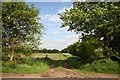
3
Track to Turf Moor Farm
Heading north off Stapleford Lane towards Turfmoor Woods. Turf Moor Farm buildings are on the right. The sign reads "Private Road, no access without permission.".
Image: © Trevor Rickard
Taken: 23 Dec 2011
0.19 miles
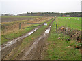
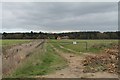
6
Lane to Turf Moor farm
Grassy track to the disused Turf Moor Farm from Newark Road
Image: © Richard Croft
Taken: 25 May 2006
0.23 miles
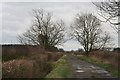
8
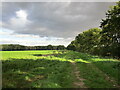
Track to Turf Moor Farm
Compare with Image
Image: © Jonathan Thacker
Taken: 27 Sep 2022
0.25 miles