IMAGES TAKEN NEAR TO
Fosse Road, NEWARK, NG23 7QA
Introduction
This page details the photographs taken nearby to Fosse Road, NG23 7QA by members of the Geograph project.
The Geograph project started in 2005 with the aim of publishing, organising and preserving representative images for every square kilometre of Great Britain, Ireland and the Isle of Man.

There are currently over 7.5m images from over14,400 individuals and you can help contribute to the project by visiting https://www.geograph.org.uk
Image Map
Images are licensed for reuse under creativecommons.org/licenses/by-sa/2.0
Notes
- Clicking on the map will re-center to the selected point.
- The higher the marker number, the further away the image location is from the centre of the postcode.
Image Listing (6 Images Found)
Images are licensed for reuse under creativecommons.org/licenses/by-sa/2.0
Image
Details
Distance
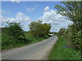
1
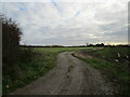
Track to South Potter Hill Farm
This is also a public bridleway.
Image: © Jonathan Thacker
Taken: 19 Nov 2020
0.03 miles
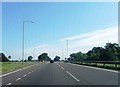
2
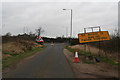
Road works on the A46 at the end of Folly Lane
Image: © Chris
Taken: 2 Mar 2014
0.07 miles
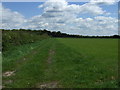
3
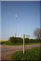
Radio Mast
Off Collingham Road near the footpath to South Potter Hill Farm
Image: © Richard Croft
Taken: 11 May 2006
0.08 miles