IMAGES TAKEN NEAR TO
Thorney Road, NEWARK, NG23 7ER
Introduction
This page details the photographs taken nearby to Thorney Road, NG23 7ER by members of the Geograph project.
The Geograph project started in 2005 with the aim of publishing, organising and preserving representative images for every square kilometre of Great Britain, Ireland and the Isle of Man.

There are currently over 7.5m images from over14,400 individuals and you can help contribute to the project by visiting https://www.geograph.org.uk
Image Map
Images are licensed for reuse under creativecommons.org/licenses/by-sa/2.0
Notes
- Clicking on the map will re-center to the selected point.
- The higher the marker number, the further away the image location is from the centre of the postcode.
Image Listing (52 Images Found)
Images are licensed for reuse under creativecommons.org/licenses/by-sa/2.0
Image
Details
Distance
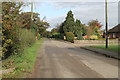
2
Wigsley
Houses in Wigsley seen from Manor Farm
Image: © Richard Croft
Taken: 16 Jul 2007
0.05 miles
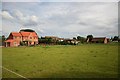
3
Manor Farm
Buildings at Manor Farm with the weighbridge office on the right
Image: © Richard Croft
Taken: 16 Jul 2007
0.06 miles
4
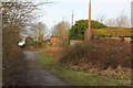
Former RAF Wigsley
New public footpath beside the overgrown and decaying remains of RAF Wigsley
Image: © Richard Croft
Taken: 11 Jan 2015
0.06 miles
5
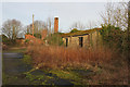
Former RAF Wigsley
Derelict buildings by the new footpath at Wigsley
Image: © Richard Croft
Taken: 11 Jan 2015
0.06 miles
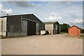
6
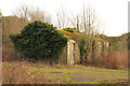
Former RAF Wigsley
Derelict building by the new footpath at Wigsley
Image: © Richard Croft
Taken: 11 Jan 2015
0.06 miles
7
Derelict cottages
Long disused cottages in Wigsley http://www.geograph.org.uk/photo/178252 now almost entirely consumed by ivy
Image: © Richard Croft
Taken: 15 Jul 2015
0.06 miles
8
Former RAF Wigsley
Former decontamination block at the site of RAF Wigsley, seen from the new footpath
Image: © Richard Croft
Taken: 11 Jan 2015
0.06 miles
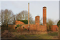
9
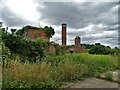
The crumbling remains of RAF Wigsley
The RAF station operated from 1942 to 1958. In this picture you can see the old decontamination block.
Image: © Neil Theasby
Taken: 29 Jul 2021
0.06 miles
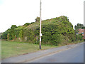
10
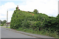
Ivy cottage, Wigsley
Not I think its proper name, which is no longer discernible, but in the circumstances quite apt!
Image: © Alan Murray-Rust
Taken: 15 Jul 2012
0.07 miles