IMAGES TAKEN NEAR TO
Station Road, NEWARK, NG23 7EL
Introduction
This page details the photographs taken nearby to Station Road, NG23 7EL by members of the Geograph project.
The Geograph project started in 2005 with the aim of publishing, organising and preserving representative images for every square kilometre of Great Britain, Ireland and the Isle of Man.

There are currently over 7.5m images from over14,400 individuals and you can help contribute to the project by visiting https://www.geograph.org.uk
Image Map
Images are licensed for reuse under creativecommons.org/licenses/by-sa/2.0
Notes
- Clicking on the map will re-center to the selected point.
- The higher the marker number, the further away the image location is from the centre of the postcode.
Image Listing (4 Images Found)
Images are licensed for reuse under creativecommons.org/licenses/by-sa/2.0
Image
Details
Distance
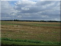
1
Electricity Pylons near North Harby
Image: © J.Hannan-Briggs
Taken: 16 Sep 2011
0.19 miles
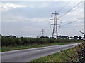
2
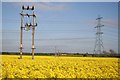
North Harby
Power lines and oil seed rape near Manor farm at North Harby, looking towards Walrudding Farm
Image: © Richard Croft
Taken: 2 May 2007
0.23 miles
3
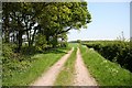
The Fifth Lane
At a crossroads known as Five Lane Ends, this was once the fifth lane that led to Broadholme Gorse and joined Manor Lane at Manor Farm, Broadholme
Image: © Richard Croft
Taken: 8 May 2008
0.25 miles