IMAGES TAKEN NEAR TO
Drinsey Nook Lane, NEWARK, NG23 7DP
Introduction
This page details the photographs taken nearby to Drinsey Nook Lane, NG23 7DP by members of the Geograph project.
The Geograph project started in 2005 with the aim of publishing, organising and preserving representative images for every square kilometre of Great Britain, Ireland and the Isle of Man.

There are currently over 7.5m images from over14,400 individuals and you can help contribute to the project by visiting https://www.geograph.org.uk
Image Map
Images are licensed for reuse under creativecommons.org/licenses/by-sa/2.0
Notes
- Clicking on the map will re-center to the selected point.
- The higher the marker number, the further away the image location is from the centre of the postcode.
Image Listing (7 Images Found)
Images are licensed for reuse under creativecommons.org/licenses/by-sa/2.0
Image
Details
Distance
1
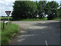
Junction of Drinsey Nook Lane with Sand Lane
Image: © JThomas
Taken: 29 Jun 2013
0.04 miles
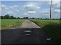
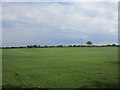
4
Turf growing near Thorney
There are extensive areas of turf growing on the light sandy soils near the River Trent.
Glover's Wood in the background.
Image: © Jonathan Thacker
Taken: 11 May 2019
0.09 miles
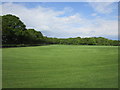
5
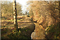
The Ring
Drain by Crow Wood known as The Ring
Image: © Richard Croft
Taken: 26 Dec 2012
0.19 miles
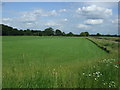
6
Turf growing near Thorney
Plot Farm in the centre of the picture.
There are extensive areas of turf growing on the light sandy soils near the River Trent.
Image: © Jonathan Thacker
Taken: 11 May 2019
0.20 miles
7
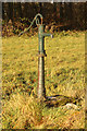
Water pump near Castle Farm
Water pump in a meadow by Castle Farm
Image: © Richard Croft
Taken: 26 Dec 2012
0.21 miles