IMAGES TAKEN NEAR TO
Main Road, NEWARK, NG23 7BH
Introduction
This page details the photographs taken nearby to Main Road, NG23 7BH by members of the Geograph project.
The Geograph project started in 2005 with the aim of publishing, organising and preserving representative images for every square kilometre of Great Britain, Ireland and the Isle of Man.

There are currently over 7.5m images from over14,400 individuals and you can help contribute to the project by visiting https://www.geograph.org.uk
Image Map
Images are licensed for reuse under creativecommons.org/licenses/by-sa/2.0
Notes
- Clicking on the map will re-center to the selected point.
- The higher the marker number, the further away the image location is from the centre of the postcode.
Image Listing (9 Images Found)
Images are licensed for reuse under creativecommons.org/licenses/by-sa/2.0
Image
Details
Distance
1
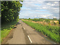
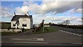
Vicarage Road
View east to the junction with the A1133 at the end.
Image: © Trevor Rickard
Taken: 22 Aug 2012
0.07 miles
3
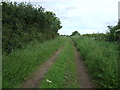
Birkland Lane
Track and footpath to the west of South Clifton
Image: © Graham Hogg
Taken: 12 Sep 2016
0.10 miles
4
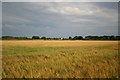
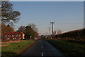
Ripening barley
Rural view at South Clifton
Image: © Richard Croft
Taken: 16 Jul 2007
0.10 miles
5
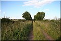
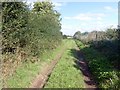
Birkland Lane
Green lane from South Clifton to Birkland Farm
Image: © Richard Croft
Taken: 15 Jul 2008
0.16 miles
8

Treasure chest of summer flowers in South Clifton
Image: © Neil Theasby
Taken: 29 Jul 2021
0.24 miles
9
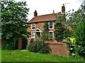
The Old Nurseries, Vicarage Road, South Clifton
Image: © Neil Theasby
Taken: 29 Jul 2021
0.25 miles