IMAGES TAKEN NEAR TO
Moor Lane, NEWARK, NG23 7BG
Introduction
This page details the photographs taken nearby to Moor Lane, NG23 7BG by members of the Geograph project.
The Geograph project started in 2005 with the aim of publishing, organising and preserving representative images for every square kilometre of Great Britain, Ireland and the Isle of Man.

There are currently over 7.5m images from over14,400 individuals and you can help contribute to the project by visiting https://www.geograph.org.uk
Image Map
Images are licensed for reuse under creativecommons.org/licenses/by-sa/2.0
Notes
- Clicking on the map will re-center to the selected point.
- The higher the marker number, the further away the image location is from the centre of the postcode.
Image Listing (29 Images Found)
Images are licensed for reuse under creativecommons.org/licenses/by-sa/2.0
Image
Details
Distance
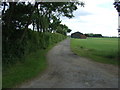
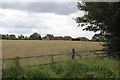
4
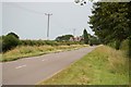
Moor Lane
Moor Lane and Moor farm near Wheatholme Lane.
Image: © Richard Croft
Taken: 2 Jul 2006
0.08 miles
6
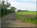
Entrance to Amblerod Farm
Leading south off Moor Lane. Two barns in view and more buildings hidden behind the trees on the left.
Image: © Trevor Rickard
Taken: 22 Aug 2012
0.08 miles
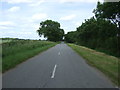
7

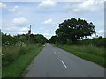
Moor Lane
Looking towards Wigsley along this quiet road
Image: © roger geach
Taken: 28 Oct 2011
0.10 miles
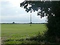
9
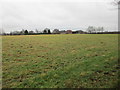
Grass field and Moorfields Farm
Moorfields Farm is marked as Amblerod Farm on OS maps.
Image: © Jonathan Thacker
Taken: 3 Feb 2018
0.11 miles
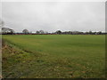
10
Amblerod Farm
Looking southwest from Moor Lane.
Image: © Alan Murray-Rust
Taken: 15 Jul 2012
0.11 miles