IMAGES TAKEN NEAR TO
Moor Lane, NEWARK, NG23 7BD
Introduction
This page details the photographs taken nearby to Moor Lane, NG23 7BD by members of the Geograph project.
The Geograph project started in 2005 with the aim of publishing, organising and preserving representative images for every square kilometre of Great Britain, Ireland and the Isle of Man.

There are currently over 7.5m images from over14,400 individuals and you can help contribute to the project by visiting https://www.geograph.org.uk
Image Map
Images are licensed for reuse under creativecommons.org/licenses/by-sa/2.0
Notes
- Clicking on the map will re-center to the selected point.
- The higher the marker number, the further away the image location is from the centre of the postcode.
Image Listing (22 Images Found)
Images are licensed for reuse under creativecommons.org/licenses/by-sa/2.0
Image
Details
Distance
1
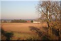
Moor Farm
View from Wheatholme Lane bridge
Image: © Richard Croft
Taken: 10 Feb 2008
0.02 miles
3

View to Moor Farm
Grass cuttings and turf field between NCN route 647 and Moor Farm
Image: © Richard Croft
Taken: 20 Mar 2012
0.08 miles
4

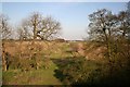
Trackbed looking east
Former railway line looking east from Wheatholme Lane bridge
Image: © Richard Croft
Taken: 10 Feb 2008
0.12 miles
5
Old railway line
View from Wheatholme Lane bridge
Image: © Richard Croft
Taken: 4 Apr 2007
0.12 miles
6

View to Cottam
View north from NCN route 647 towards Cottam Power Station
Image: © Richard Croft
Taken: 23 Jan 2012
0.13 miles
7
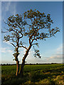
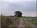
Lone tree
A lone tree on Moor Lane catches late evening sun on the longest day
Image: © Richard Croft
Taken: 21 Jun 2011
0.14 miles
8
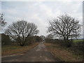
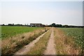
Track at the end of Moor Lane
Near Moor Farm
Image: © J.Hannan-Briggs
Taken: 16 Sep 2011
0.14 miles
10
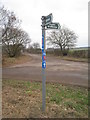
Signpost at the junction of Mill Lane and Moor Lane
Image: © Jonathan Thacker
Taken: 3 Jan 2011
0.17 miles