IMAGES TAKEN NEAR TO
Herrod Close, NEWARK, NG23 6UA
Introduction
This page details the photographs taken nearby to Herrod Close, NG23 6UA by members of the Geograph project.
The Geograph project started in 2005 with the aim of publishing, organising and preserving representative images for every square kilometre of Great Britain, Ireland and the Isle of Man.

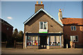
There are currently over 7.5m images from over14,400 individuals and you can help contribute to the project by visiting https://www.geograph.org.uk
Image Map
Images are licensed for reuse under creativecommons.org/licenses/by-sa/2.0
Notes
- Clicking on the map will re-center to the selected point.
- The higher the marker number, the further away the image location is from the centre of the postcode.
Image Listing (88 Images Found)
Images are licensed for reuse under creativecommons.org/licenses/by-sa/2.0
Image
Details
Distance
1
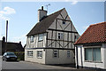
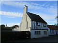
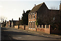
The Old Bakehouse
The bakehouse may be old, but the timbers aren't. An enigmatic house on Main Street, with a steeply pitched roof and deep eaves suggesting 18th century origins.
Image: © Richard Croft
Taken: 1 Apr 2012
0.04 miles
2
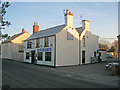
The Lord Nelson
Public house on the east side of Main Street.
Image: © Trevor Rickard
Taken: 16 Jan 2012
0.04 miles
3
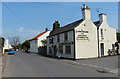
The Lord Nelson in Sutton on Trent
A public house on Main Street.
Image: © Mat Fascione
Taken: 7 May 2016
0.05 miles
4
Woolfit House
Main Street Sutton-on-Trent with Woolfit house, formerly Woolfitt's Grocery shop
Image: © Richard Croft
Taken: 27 May 2013
0.05 miles
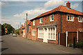
5
Sutton-on-Trent library
Village library in a former shop on Main Street
Image: © Richard Croft
Taken: 4 Feb 2013
0.07 miles
6
The Bakehouse, Sutton on Trent
Probably a late seventeenth century house but much altered with false timbering.
Image: © Jonathan Thacker
Taken: 5 Nov 2021
0.09 miles
9
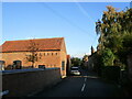
Main Street
View south along Main Street with Vine House http://www.geograph.org.uk/photo/2036669 on the right
Image: © Richard Croft
Taken: 4 Feb 2013
0.10 miles
10
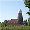
Sutton-on-Trent Windmill
Built between 1811 and 1814, it was a typical 4-sail tower mill with fantail cap and (latterly at least) spring sails. The current cap is a modern restoration and the tower now contains residential accommodation as an annexe to the modern house in front. The tower is Listed Grade II.
Image: © Alan Murray-Rust
Taken: 24 Jul 2014
0.10 miles