IMAGES TAKEN NEAR TO
Normanton Road, NEWARK, NG23 6TN
Introduction
This page details the photographs taken nearby to Normanton Road, NG23 6TN by members of the Geograph project.
The Geograph project started in 2005 with the aim of publishing, organising and preserving representative images for every square kilometre of Great Britain, Ireland and the Isle of Man.

There are currently over 7.5m images from over14,400 individuals and you can help contribute to the project by visiting https://www.geograph.org.uk
Image Map
Images are licensed for reuse under creativecommons.org/licenses/by-sa/2.0
Notes
- Clicking on the map will re-center to the selected point.
- The higher the marker number, the further away the image location is from the centre of the postcode.
Image Listing (6 Images Found)
Images are licensed for reuse under creativecommons.org/licenses/by-sa/2.0
Image
Details
Distance
1
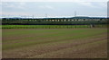
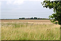
Fields near Mount Pleasant Farm
Field view from the path passing east of the farm. The fence marks the line of the farm track.
Image: © Andrew Hill
Taken: 18 Sep 2010
0.08 miles
2
Track to Mount Pleasant Farm
Looking south off Tuxford Road.
Image: © J.Hannan-Briggs
Taken: 24 Apr 2016
0.17 miles
3
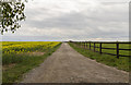
By the road to Tuxford
View from the path approaching the road from the south. In the other direction the lane goes to Normanton on Trent.
Image: © Andrew Hill
Taken: 18 Sep 2010
0.20 miles
4
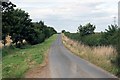
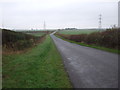
Country road
Heading out of Weston , power lines can be seen which led to High Marnham power station now out of use.
Image: © roger geach
Taken: 23 Aug 2009
0.23 miles
5
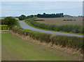
View from Hawbush Road
Looking across to The Ruddings Farm.
Image: © Alan Murray-Rust
Taken: 1 Aug 2014
0.24 miles