IMAGES TAKEN NEAR TO
Meadow Lane, NEWARK, NG23 6SU
Introduction
This page details the photographs taken nearby to Meadow Lane, NG23 6SU by members of the Geograph project.
The Geograph project started in 2005 with the aim of publishing, organising and preserving representative images for every square kilometre of Great Britain, Ireland and the Isle of Man.

There are currently over 7.5m images from over14,400 individuals and you can help contribute to the project by visiting https://www.geograph.org.uk
Image Map
Images are licensed for reuse under creativecommons.org/licenses/by-sa/2.0
Notes
- Clicking on the map will re-center to the selected point.
- The higher the marker number, the further away the image location is from the centre of the postcode.
Image Listing (49 Images Found)
Images are licensed for reuse under creativecommons.org/licenses/by-sa/2.0
Image
Details
Distance
1
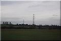
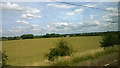
Field by the railway
Looking along the main line northbound near Weston.
Image: © Andrew Hill
Taken: 18 Sep 2010
0.11 miles
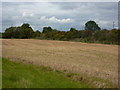
2
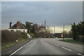
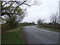
Great North Road at Weston
The old road (B1164) runs roughly parallel to the A1.
Image: © J.Hannan-Briggs
Taken: 20 Nov 2015
0.14 miles
3
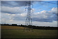
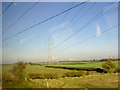
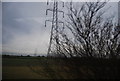
Fields outside Weston, from the railway
Across the landscape march pylon lines (two in shot and a third just behind the camera) fanning out from the High Marnham power station, some miles east by the River Trent.
Image: © Christopher Hilton
Taken: 11 Jul 2015
0.14 miles
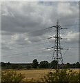
5
Power lines cross the East Coast main rail line
Image: © Steve Fareham
Taken: 29 Oct 2008
0.15 miles
7
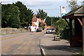
Weston Village
taken from outside the church
Image: © roger geach
Taken: 23 Aug 2009
0.16 miles