IMAGES TAKEN NEAR TO
Grassthorpe Road, NEWARK, NG23 6RX
Introduction
This page details the photographs taken nearby to Grassthorpe Road, NG23 6RX by members of the Geograph project.
The Geograph project started in 2005 with the aim of publishing, organising and preserving representative images for every square kilometre of Great Britain, Ireland and the Isle of Man.

There are currently over 7.5m images from over14,400 individuals and you can help contribute to the project by visiting https://www.geograph.org.uk
Image Map
Images are licensed for reuse under creativecommons.org/licenses/by-sa/2.0
Notes
- Clicking on the map will re-center to the selected point.
- The higher the marker number, the further away the image location is from the centre of the postcode.
Image Listing (14 Images Found)
Images are licensed for reuse under creativecommons.org/licenses/by-sa/2.0
Image
Details
Distance
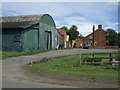
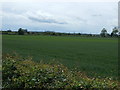
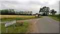
2
Towards Holly Farm
Looking north towards Low Marnham and Holly Farm
Image: © Richard Croft
Taken: 5 Apr 2007
0.09 miles
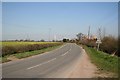
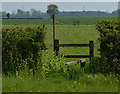
4
Lane to Grassthorpe
Near Holly Farm.
Image: © Julian P Guffogg
Taken: 24 Apr 2016
0.09 miles
7
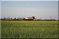
Trantman Lodge
View across a field of rape towards Trentman Lodge
Image: © Richard Croft
Taken: 5 Apr 2007
0.19 miles
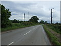
9
Fledborough Road becomes Marnham Road
At Low Marnham
Image: © Chris Morgan
Taken: 13 Jul 2015
0.22 miles
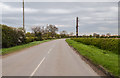
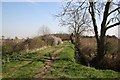
10
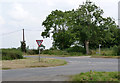
The end of Brotts Lane
Grassthorpe Road (off to the right) becomes Marnham Road at this point.
Image: © Alan Murray-Rust
Taken: 1 Aug 2014
0.24 miles