IMAGES TAKEN NEAR TO
Mill Lane, NEWARK, NG23 6RW
Introduction
This page details the photographs taken nearby to Mill Lane, NG23 6RW by members of the Geograph project.
The Geograph project started in 2005 with the aim of publishing, organising and preserving representative images for every square kilometre of Great Britain, Ireland and the Isle of Man.

There are currently over 7.5m images from over14,400 individuals and you can help contribute to the project by visiting https://www.geograph.org.uk
Image Map
Images are licensed for reuse under creativecommons.org/licenses/by-sa/2.0
Notes
- Clicking on the map will re-center to the selected point.
- The higher the marker number, the further away the image location is from the centre of the postcode.
Image Listing (67 Images Found)
Images are licensed for reuse under creativecommons.org/licenses/by-sa/2.0
Image
Details
Distance
1
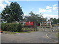
St. Matthew's Church of England Primary School, Normanton on Trent
A C(onsortium of) L(ocal) A(uthorities) S(pecial) P(rogramme) build from the 1960s.
Image: © Jonathan Thacker
Taken: 28 Jul 2012
0.06 miles
2
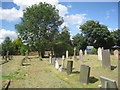
The cemetery, Normanton on Trent
Across the road from the parish church.
Image: © Jonathan Thacker
Taken: 28 Jul 2012
0.07 miles
3
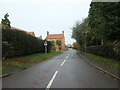
Mill Lane, Normanton on Trent
Once leading to Normanton windmill. Now lined with new houses and leading to the village school.
Image: © Christine Johnstone
Taken: 26 Nov 2022
0.07 miles
4
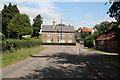
Threeways
Threeways cottage at the junction in Normanton-on-Trent
Image: © Richard Croft
Taken: 4 Jul 2010
0.09 miles
5
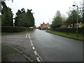
The east-west road through Normanton on Trent
Where Tuxford Road morphs into Eastgate.
Image: © Christine Johnstone
Taken: 26 Nov 2022
0.10 miles
6
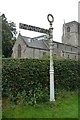
Old Direction Sign - Signpost by Tuxford Road, Normanton on Trent Parish
Annulus finial - 2 arms; Old cast iron, annular finial (NOTTS CC) by the UC road, in parish of Normanton on Trent (Bassetlaw District), junction of Tuxford Road, South Street and Eastgate, outside the church, on grass verge.
To be surveyed.
Milestone Society National ID: NT_SK7969
Image: © Milestone Society
Taken: Unknown
0.10 miles
7
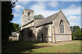
St.Matthew's church
Largely 14th and 15th century church at Normanton-on-Trent
Image: © Richard Croft
Taken: 4 Jul 2010
0.10 miles
8
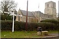
St. Matthew's church Normanton on Trent
Junction with Tuxford Road.
Image: © Steve Fareham
Taken: 20 Feb 2009
0.10 miles
9
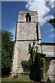
St.Matthew's tower
Fifteenth century tower of St.Matthew's church
Image: © Richard Croft
Taken: 4 Jul 2010
0.10 miles
10
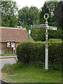
Fingerpost, Tuxford Road/Eastgate, Normanton-on-Trent
Notts C C traditional cast-iron with annulus finial.
Image: © Alan Murray-Rust
Taken: 1 Aug 2014
0.10 miles