IMAGES TAKEN NEAR TO
Willow Holt, NEWARK, NG23 6QT
Introduction
This page details the photographs taken nearby to Willow Holt, NG23 6QT by members of the Geograph project.
The Geograph project started in 2005 with the aim of publishing, organising and preserving representative images for every square kilometre of Great Britain, Ireland and the Isle of Man.

There are currently over 7.5m images from over14,400 individuals and you can help contribute to the project by visiting https://www.geograph.org.uk
Image Map
Images are licensed for reuse under creativecommons.org/licenses/by-sa/2.0
Notes
- Clicking on the map will re-center to the selected point.
- The higher the marker number, the further away the image location is from the centre of the postcode.
Image Listing (45 Images Found)
Images are licensed for reuse under creativecommons.org/licenses/by-sa/2.0
Image
Details
Distance
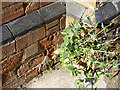
1
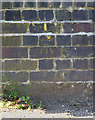
Bench mark, Palmer Road, Sutton-on-Trent
See http://www.geograph.org.uk/photo/4098829 for location.
Image: © Alan Murray-Rust
Taken: 24 Jul 2014
0.08 miles
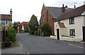
2
Palmer Road, Sutton-on-Trent
There is a bench mark http://www.geograph.org.uk/photo/4098827 in the centre of the parapet on the left.
Image: © Alan Murray-Rust
Taken: 24 Jul 2014
0.08 miles
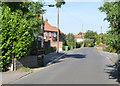
4
High Street and chapel, Sutton on Trent
Looking along the village High Street past the Methodist chapel.
Image: © Andrew Hill
Taken: 18 Sep 2010
0.15 miles
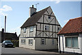
5
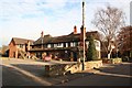
The Old England Hotel
A mock Tudor Inn established when Sutton on Trent was on the Great North Road - now bypassed, the Old England Hotel is on a quiet village lane.
Image: © Richard Croft
Taken: Unknown
0.15 miles
6
Bench mark, Sutton-on-Trent Methodist Church
See http://www.geograph.org.uk/photo/4098856 for location.
Image: © Alan Murray-Rust
Taken: 24 Jul 2014
0.15 miles
7
Sutton-on-Trent Methodist Church
Not a flattering shot of the Church, but taken to locate the bench mark http://www.geograph.org.uk/photo/4098855 which is just to the right of the trunk of the tree. The low sun precluded taking a shot from the other direction.
Image: © Alan Murray-Rust
Taken: 24 Jul 2014
0.15 miles
8
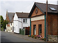
The Old Coop, High Street, Sutton-on-Trent
A free-standing retail building like this in a village is odds-on to have been the local Co-op, and this is confirmed by the current house name.
Image: © Alan Murray-Rust
Taken: 1 Aug 2014
0.15 miles
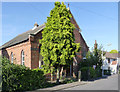
9
The Old Bakehouse
The bakehouse may be old, but the timbers aren't. An enigmatic house on Main Street, with a steeply pitched roof and deep eaves suggesting 18th century origins.
Image: © Richard Croft
Taken: 1 Apr 2012
0.15 miles
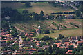
10
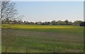
Oil Seed Rape field
As seen from the East Coast Main Line.
Image: © Julian P Guffogg
Taken: 6 May 2013
0.16 miles