IMAGES TAKEN NEAR TO
Old Great North Road, NEWARK, NG23 6QL
Introduction
This page details the photographs taken nearby to Old Great North Road, NG23 6QL by members of the Geograph project.
The Geograph project started in 2005 with the aim of publishing, organising and preserving representative images for every square kilometre of Great Britain, Ireland and the Isle of Man.

There are currently over 7.5m images from over14,400 individuals and you can help contribute to the project by visiting https://www.geograph.org.uk
Image Map
Images are licensed for reuse under creativecommons.org/licenses/by-sa/2.0
Notes
- Clicking on the map will re-center to the selected point.
- The higher the marker number, the further away the image location is from the centre of the postcode.
Image Listing (33 Images Found)
Images are licensed for reuse under creativecommons.org/licenses/by-sa/2.0
Image
Details
Distance
1
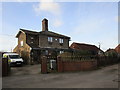
The former station building, Crow Park
Opened by the Great Northern Railway in 1882 and closed in 1958. The station was named Crow Park rather than the more obvious Sutton on Trent to avoid confusion with the many other Suttons.
Image: © Jonathan Thacker
Taken: 20 Dec 2014
0.07 miles
2
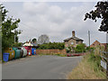
Site of level crossing, Sutton-on-Trent
Here the Old Great North Road crossed the East Coast Main Line. The crossing keepers' building was a double cottage, presumably reflecting the importance of both road and railway. Now named The Old Station House, although this is strictly incorrect.
Image: © Alan Murray-Rust
Taken: 1 Aug 2014
0.08 miles
3
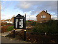
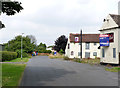
Notice board and amenity area
In a dull suburban part of Sutton on Trent.
Image: © Jonathan Thacker
Taken: 20 Dec 2014
0.08 miles
4
Crow Park (for Sutton-on-Trent) railway station site, Nottinghamshire
Opened in 1882 by the Great Northern Railway on its line from Peterborough to Doncaster, this station closed to passengers in 1958 and completely in 1964.
View north towards Tuxford and Doncaster.
Image: © Nigel Thompson
Taken: 11 Nov 2012
0.09 miles
5
The Old Great North Road, Sutton-on-Trent
Originally the road carried on straight across the railway by means of a level crossing. On the right is the now empty Nag's Head pub http://www.geograph.org.uk/photo/4103812.
Image: © Alan Murray-Rust
Taken: 1 Aug 2014
0.10 miles
6
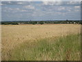
View towards Sutton on Trent and Lincoln
Lincoln Cathedral can just be seen on the ridge slightly to the right of the centre of the picture.
Image: © Jonathan Thacker
Taken: 28 Jul 2012
0.10 miles
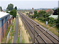
7
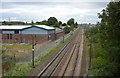
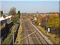
Railway line at Sutton on Trent
The main line heading north, seen from the bridge on the old Great North Road (now the B1164).
Image: © Andrew Hill
Taken: 18 Sep 2010
0.10 miles
9
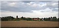
The site of Crow Park Station
The cottage with the chimneys marks the location of a level crossing which was at the far end of the station. The latter was closed to passengers in 1958 and has disappeared without trace.
It is unclear why the station was named Crow Park, a neighbouring estate, rather than the village of Sutton-on-Trent which it really serves.
The footpath on the left is a replacement for the pedestrian facility across the railway at the level crossing site.
Image: © Alan Murray-Rust
Taken: 1 Aug 2014
0.11 miles
10
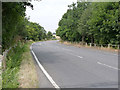
Great North Road, Sutton-on-Trent
Part of the roadway built with the bridge over the East Coast Main Line to replace a level crossing.
Image: © Alan Murray-Rust
Taken: 1 Aug 2014
0.12 miles