IMAGES TAKEN NEAR TO
Norwell Woodhouse, NEWARK, NG23 6NG
Introduction
This page details the photographs taken nearby to NG23 6NG by members of the Geograph project.
The Geograph project started in 2005 with the aim of publishing, organising and preserving representative images for every square kilometre of Great Britain, Ireland and the Isle of Man.

There are currently over 7.5m images from over14,400 individuals and you can help contribute to the project by visiting https://www.geograph.org.uk
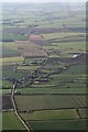
Image Map
Images are licensed for reuse under creativecommons.org/licenses/by-sa/2.0
Notes
- Clicking on the map will re-center to the selected point.
- The higher the marker number, the further away the image location is from the centre of the postcode.
Image Listing (8 Images Found)
Images are licensed for reuse under creativecommons.org/licenses/by-sa/2.0
Image
Details
Distance
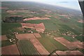
5
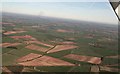
From above Kersall, across A616 to Norwell Woodhouse and beyond: aerial 2017
Image: © Chris
Taken: 25 Mar 2017
0.18 miles
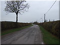
6
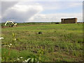
Straw House and Digger
Despite all the warnings from the story of the three little pigs it would appear people are still building houses from straw.
Image: © Michael Patterson
Taken: 23 May 2006
0.20 miles
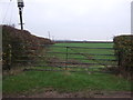
8
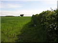
Footpath to Caunton
This footpath joins a multitude of other paths that lead to Caunton.
Image: © Michael Patterson
Taken: 23 May 2006
0.23 miles