IMAGES TAKEN NEAR TO
Ossington Lane, NEWARK, NG23 6ND
Introduction
This page details the photographs taken nearby to Ossington Lane, NG23 6ND by members of the Geograph project.
The Geograph project started in 2005 with the aim of publishing, organising and preserving representative images for every square kilometre of Great Britain, Ireland and the Isle of Man.

There are currently over 7.5m images from over14,400 individuals and you can help contribute to the project by visiting https://www.geograph.org.uk
Image Map
Images are licensed for reuse under creativecommons.org/licenses/by-sa/2.0
Notes
- Clicking on the map will re-center to the selected point.
- The higher the marker number, the further away the image location is from the centre of the postcode.
Image Listing (4 Images Found)
Images are licensed for reuse under creativecommons.org/licenses/by-sa/2.0
Image
Details
Distance
1
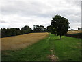
Grassy track and oats near Primrose Farm
This is all marked as access land so seeing some planted with oats comes as something of a surprise.
Image: © Jonathan Thacker
Taken: 9 Sep 2016
0.08 miles
2
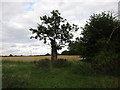
Decapitated ash
This ash tree has suffered greatly but still survives.
Image: © Jonathan Thacker
Taken: 9 Sep 2016
0.14 miles
3
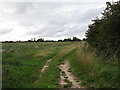
Track to Copthorne Farm and Green Lane
Image: © Jonathan Thacker
Taken: 9 Sep 2016
0.20 miles
4
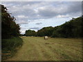
Bottom Long Syke
Technically part of South Field but unsuitable for cultivation so given over to grass.
Image: © Jonathan Thacker
Taken: 9 Sep 2016
0.20 miles