IMAGES TAKEN NEAR TO
Highland Lane, NEWARK, NG23 6LN
Introduction
This page details the photographs taken nearby to Highland Lane, NG23 6LN by members of the Geograph project.
The Geograph project started in 2005 with the aim of publishing, organising and preserving representative images for every square kilometre of Great Britain, Ireland and the Isle of Man.

There are currently over 7.5m images from over14,400 individuals and you can help contribute to the project by visiting https://www.geograph.org.uk
Image Map
Images are licensed for reuse under creativecommons.org/licenses/by-sa/2.0
Notes
- Clicking on the map will re-center to the selected point.
- The higher the marker number, the further away the image location is from the centre of the postcode.
Image Listing (8 Images Found)
Images are licensed for reuse under creativecommons.org/licenses/by-sa/2.0
Image
Details
Distance
1
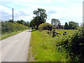
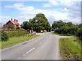
Highland Cottages
Highland Cottages can be seen to the right of the road.
Image: © James Hill
Taken: 28 Jul 2007
0.02 miles
2
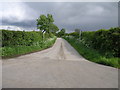
Fast Bridleway
This bridleway is the first I have seen with a speed limit. It leads from Ossington to Norwell.
Image: © Michael Patterson
Taken: 23 May 2006
0.02 miles
3
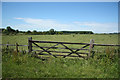
Ossington meadow
A meadow off Highland Lane at Ossington
Image: © Richard Croft
Taken: 26 Jun 2011
0.06 miles
4
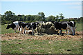
Cattle at Ossington
Cattle feeding in a meadow at Ossington
Image: © Richard Croft
Taken: 26 Jun 2011
0.11 miles
5
Highland Farm
Highland Farm in Ossington.
Image: © James Hill
Taken: 28 Jul 2007
0.12 miles
6
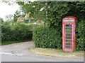
Ossington telephone kiosk
K6 kiosk, in rather distressed state, but still with its telephone installed.
Image: © Alan Murray-Rust
Taken: 1 Aug 2014
0.21 miles
7
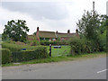
Rose Cottage, Ossington
18th century brick-built cottage, Listed Grade II.
The attached cottages to the right are not included in the listing.
Image: © Alan Murray-Rust
Taken: 1 Aug 2014
0.21 miles
8
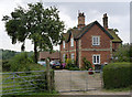
Estate cottages, Ossington
The 1875 1:2500 map shows the village Post Office located in the cottages.
Image: © Alan Murray-Rust
Taken: 1 Aug 2014
0.24 miles