IMAGES TAKEN NEAR TO
Glebelands, NEWARK, NG23 6FH
Introduction
This page details the photographs taken nearby to Glebelands, NG23 6FH by members of the Geograph project.
The Geograph project started in 2005 with the aim of publishing, organising and preserving representative images for every square kilometre of Great Britain, Ireland and the Isle of Man.

There are currently over 7.5m images from over14,400 individuals and you can help contribute to the project by visiting https://www.geograph.org.uk
Image Map
Images are licensed for reuse under creativecommons.org/licenses/by-sa/2.0
Notes
- Clicking on the map will re-center to the selected point.
- The higher the marker number, the further away the image location is from the centre of the postcode.
Image Listing (91 Images Found)
Images are licensed for reuse under creativecommons.org/licenses/by-sa/2.0
Image
Details
Distance
1
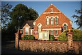
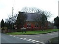
North Muskham Methodist Church
Methodist Church on Main Street
Image: © Richard Croft
Taken: 19 Aug 2009
0.03 miles
2
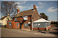
The Crown Inn
Pub on Main Street, closed for three years and still for sale
Image: © Richard Croft
Taken: 1 Apr 2012
0.04 miles
3
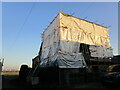
Building work, Marsh Lane, North Muskham
Image: © Jonathan Thacker
Taken: 24 Jan 2023
0.05 miles
5
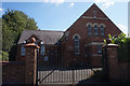
Methodist Church, North Muskham
Church on corner of Main Street and Meadow Close.
Image: © Michael Westley
Taken: 24 Jan 2010
0.05 miles
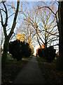
6
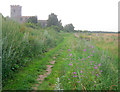
Public footpath at the back of St Wilfrid's Church
Heading northwards along a well-trodden path used by the local dog walkers.
Image: © Trevor Rickard
Taken: 12 Aug 2012
0.07 miles
8
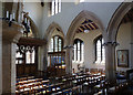
Church of St Wilfrid, North Muskham
Looking through to the south aisle, built c1480.
Image: © Alan Murray-Rust
Taken: 24 Jul 2014
0.08 miles
9
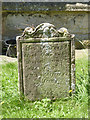
Church of St Wilfrid, North Muskham
An early gravestone, to Elizabeth Dixson, died 1727 aged 17. The inscription is more legible than many from this period.
Image: © Alan Murray-Rust
Taken: 24 Jul 2014
0.08 miles
10
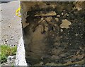
Ordnance Survey Cut Mark
This OS cut mark can be found on the east face of St Wilfrid's Church. It marks a point 12.341m above mean sea level.
Image: © Adrian Dust
Taken: 5 Jun 2016
0.08 miles