IMAGES TAKEN NEAR TO
The Park, NEWARK, NG23 6EW
Introduction
This page details the photographs taken nearby to The Park, NG23 6EW by members of the Geograph project.
The Geograph project started in 2005 with the aim of publishing, organising and preserving representative images for every square kilometre of Great Britain, Ireland and the Isle of Man.

There are currently over 7.5m images from over14,400 individuals and you can help contribute to the project by visiting https://www.geograph.org.uk
Image Map
Images are licensed for reuse under creativecommons.org/licenses/by-sa/2.0
Notes
- Clicking on the map will re-center to the selected point.
- The higher the marker number, the further away the image location is from the centre of the postcode.
Image Listing (30 Images Found)
Images are licensed for reuse under creativecommons.org/licenses/by-sa/2.0
Image
Details
Distance
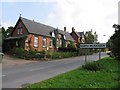
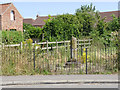
2
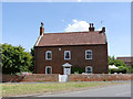
The Shades, North Muskham
A late 18th century 3-bay house at the northern end of the village. Listed Grade II.
Image: © Alan Murray-Rust
Taken: 24 Jul 2014
0.06 miles
3
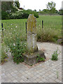
North Muskham cross
Base and lower shaft of a 14th century roadside cross on the old Great North Road at North Muskham
Image: © Richard Croft
Taken: 1 Aug 2011
0.06 miles
4
North Muskham Cross
Base of a 14th century cross. Although the English Heritage listed refers to it as 'Village Cross', its purpose was to mark the point from which it was possible to ford the River Trent to Holme, where there are the remains of a similar cross. Listed Grade II, also a Scheduled Monument.
Image: © Alan Murray-Rust
Taken: 24 Jul 2014
0.06 miles
5
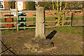
North Muskham Cross
Grade II listed 14th century base and broken octagonal cross shaft by the Old Great North Road at North Muskham
Image: © Richard Croft
Taken: 22 Mar 2021
0.06 miles
7
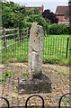
Old Wayside Cross - moved to Main Street, North Muskham Parish
North Muskham Cross, old shaft and base by the wayside, in parish of North Muskham (Newark And Sherwood District), Main Street, in its own fenced enclosure, East side of road, associated with the ferry crossing.
Grade II listed. List Entry Number: 1369985
https://historicengland.org.uk/listing/the-list/list-entry/1369985
Scheduled Monument. List Entry Number: 1018131
https://historicengland.org.uk/listing/the-list/list-entry/1018131
To be surveyed
Milestone Society National ID: NTNW_NOR
Image: © Milestone Society
Taken: Unknown
0.06 miles
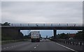
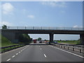
9
Vicarage Lane Bridge over the A1 (Great North Road)
Image: © N Chadwick
Taken: 25 Feb 2011
0.07 miles