IMAGES TAKEN NEAR TO
South Muskham, NEWARK, NG23 6DX
Introduction
This page details the photographs taken nearby to NG23 6DX by members of the Geograph project.
The Geograph project started in 2005 with the aim of publishing, organising and preserving representative images for every square kilometre of Great Britain, Ireland and the Isle of Man.

There are currently over 7.5m images from over14,400 individuals and you can help contribute to the project by visiting https://www.geograph.org.uk
Image Map
Images are licensed for reuse under creativecommons.org/licenses/by-sa/2.0
Notes
- Clicking on the map will re-center to the selected point.
- The higher the marker number, the further away the image location is from the centre of the postcode.
Image Listing (3 Images Found)
Images are licensed for reuse under creativecommons.org/licenses/by-sa/2.0
Image
Details
Distance
1
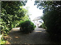
Approaching Moor House
The bridleway keeps left, away from the house
Image: © John Slater
Taken: 7 Jul 2018
0.01 miles
2
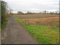
Farm track near Moor House
Heading west towards Bathley across mainly arable land.
Image: © Trevor Rickard
Taken: 9 Jan 2012
0.10 miles
3
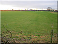
Meadow near South Muskham
Looking south across a large meadow with a small stream running across it on the right. In the distance is the sugar factory at Newark and to the left is the scaffold-covered tower of St Wilfrid's Church at South Muskham.
Image: © Trevor Rickard
Taken: 9 Jan 2012
0.25 miles