IMAGES TAKEN NEAR TO
Vicarage Lane, NEWARK, NG23 6DU
Introduction
This page details the photographs taken nearby to Vicarage Lane, NG23 6DU by members of the Geograph project.
The Geograph project started in 2005 with the aim of publishing, organising and preserving representative images for every square kilometre of Great Britain, Ireland and the Isle of Man.

There are currently over 7.5m images from over14,400 individuals and you can help contribute to the project by visiting https://www.geograph.org.uk
Image Map
Images are licensed for reuse under creativecommons.org/licenses/by-sa/2.0
Notes
- Clicking on the map will re-center to the selected point.
- The higher the marker number, the further away the image location is from the centre of the postcode.
Image Listing (5 Images Found)
Images are licensed for reuse under creativecommons.org/licenses/by-sa/2.0
Image
Details
Distance
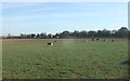
1
East Coast main railway line crossing North Muskham
A Great Central train went through.
Image: © Steve Fareham
Taken: 25 Mar 2013
0.11 miles
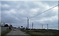
2
Norwell Crossing, North Muskham
Notice advertising consultation about the closure of the crossing.
Image: © Alan Murray-Rust
Taken: 24 Jul 2014
0.12 miles
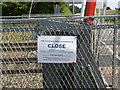
3
Norwell Crossing, North Muskham
The crossing is due to be closed within 3-4 years as part of Network Rail's programme of level crossing removal. A new bridge is proposed.
Image: © Alan Murray-Rust
Taken: 24 Jul 2014
0.13 miles
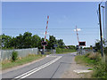
4
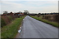
Entering North Muskham
East Coast Main Line Railway level crossing ahead.
Image: © Julian P Guffogg
Taken: 13 Jan 2016
0.20 miles