IMAGES TAKEN NEAR TO
Muskham Lane, NEWARK, NG23 6DD
Introduction
This page details the photographs taken nearby to Muskham Lane, NG23 6DD by members of the Geograph project.
The Geograph project started in 2005 with the aim of publishing, organising and preserving representative images for every square kilometre of Great Britain, Ireland and the Isle of Man.

There are currently over 7.5m images from over14,400 individuals and you can help contribute to the project by visiting https://www.geograph.org.uk
Image Map
Images are licensed for reuse under creativecommons.org/licenses/by-sa/2.0
Notes
- Clicking on the map will re-center to the selected point.
- The higher the marker number, the further away the image location is from the centre of the postcode.
Image Listing (8 Images Found)
Images are licensed for reuse under creativecommons.org/licenses/by-sa/2.0
Image
Details
Distance

3
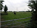
Paddock and Pylons
And a nosey horse or one that has a conditioned reflex that associates people with food and not photography. The pylons are heading to Staythorpe sub-station.
Image: © Michael Patterson
Taken: 16 Jun 2006
0.08 miles
4
Footpath near Grange Farm
Heading north-west towards Manor Farm. Even though the farmer has kindly left a track to show the way, the wet claggy soil turned my walking boots into a pair of large mud balls by the time I reached the other side.
Image: © Trevor Rickard
Taken: 9 Jan 2012
0.16 miles
5

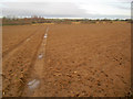
The first signs of spring
All around are the first signs of spring but here winter greys still predominate.
Image: © Jonathan Thacker
Taken: 31 Mar 2014
0.18 miles
6
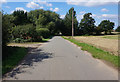
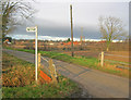
The approach to Bathley
The road from North Muskham, unsurprisingly called Muskham Lane.
Image: © Alan Murray-Rust
Taken: 24 Jul 2014
0.21 miles
7
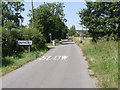
Muskham Lane
Heading west towards Bathley. The 'Restricted Byway' sign on the left points to the appropriately-named Green Lane, which is rather overgrown, but passable on foot.
Image: © Trevor Rickard
Taken: 9 Jan 2012
0.21 miles
8
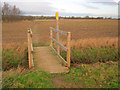
Footbridge near Grange Farm
Taking the public footpath over a drainage ditch east of Bathley. This well-used path has the makings of being the village dog-walking circuit.
Image: © Trevor Rickard
Taken: 9 Jan 2012
0.25 miles