IMAGES TAKEN NEAR TO
Caunton, NEWARK, NG23 6BE
Introduction
This page details the photographs taken nearby to NG23 6BE by members of the Geograph project.
The Geograph project started in 2005 with the aim of publishing, organising and preserving representative images for every square kilometre of Great Britain, Ireland and the Isle of Man.

There are currently over 7.5m images from over14,400 individuals and you can help contribute to the project by visiting https://www.geograph.org.uk
Image Map
Images are licensed for reuse under creativecommons.org/licenses/by-sa/2.0
Notes
- Clicking on the map will re-center to the selected point.
- The higher the marker number, the further away the image location is from the centre of the postcode.
Image Listing (7 Images Found)
Images are licensed for reuse under creativecommons.org/licenses/by-sa/2.0
Image
Details
Distance
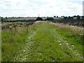
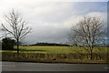
3
Footpath to Kelham
Rather muddy at this time of year.
Image: © Jonathan Thacker
Taken: 20 Feb 2015
0.18 miles
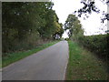
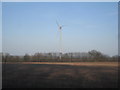
5
Cold Harbour Plantation
From the side of the A616.
Two old sections of road form useful lay-bys here, though the one on the north east side of the road, where this was taken from is decidedly bumpy and narrow and not officially signed as a parking spot. See Image
Image: © David Lally
Taken: 9 Feb 2010
0.20 miles
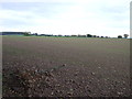
7
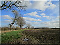
Prepared field, Muskham Woodhouse
Choulers Gorse in the distance.
Image: © Jonathan Thacker
Taken: 13 Nov 2020
0.21 miles