IMAGES TAKEN NEAR TO
Caunton, NEWARK, NG23 6BD
Introduction
This page details the photographs taken nearby to NG23 6BD by members of the Geograph project.
The Geograph project started in 2005 with the aim of publishing, organising and preserving representative images for every square kilometre of Great Britain, Ireland and the Isle of Man.

There are currently over 7.5m images from over14,400 individuals and you can help contribute to the project by visiting https://www.geograph.org.uk
Image Map
Images are licensed for reuse under creativecommons.org/licenses/by-sa/2.0
Notes
- Clicking on the map will re-center to the selected point.
- The higher the marker number, the further away the image location is from the centre of the postcode.
Image Listing (5 Images Found)
Images are licensed for reuse under creativecommons.org/licenses/by-sa/2.0
Image
Details
Distance
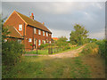
1
Muskham Woodhouse Farm
Looking eastwards to the very impressive new build occupying a good viewpoint on the ridge. A big sky is developing over the big house.
Image: © Trevor Rickard
Taken: 19 Aug 2012
0.02 miles
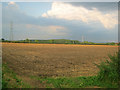
2
Muskham Woodhouse Farm
Looking east at one of several attractive dwellings situated at the end of the lane.
Image: © Trevor Rickard
Taken: 19 Aug 2012
0.05 miles
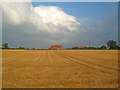
3
Arable land at Muskham Woodhouse Farm
Looking north-east towards Cold Harbour Plantation and the wind turbine at Dean Hall Farm (see Image ).
Image: © Trevor Rickard
Taken: 19 Aug 2012
0.11 miles
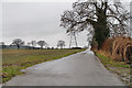
4
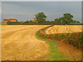
Path to Muskham Woodhouse Farm
Sweeping eastwards along the hedge towards the small group of houses on the ridge.
Image: © Trevor Rickard
Taken: 19 Aug 2012
0.15 miles