IMAGES TAKEN NEAR TO
Ollerton Road, NEWARK, NG23 6BB
Introduction
This page details the photographs taken nearby to Ollerton Road, NG23 6BB by members of the Geograph project.
The Geograph project started in 2005 with the aim of publishing, organising and preserving representative images for every square kilometre of Great Britain, Ireland and the Isle of Man.

There are currently over 7.5m images from over14,400 individuals and you can help contribute to the project by visiting https://www.geograph.org.uk
Image Map
Images are licensed for reuse under creativecommons.org/licenses/by-sa/2.0
Notes
- Clicking on the map will re-center to the selected point.
- The higher the marker number, the further away the image location is from the centre of the postcode.
Image Listing (6 Images Found)
Images are licensed for reuse under creativecommons.org/licenses/by-sa/2.0
Image
Details
Distance
1
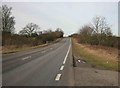
The A616 nr Caunton
looking towards the Ollerton direction , Newark is behind me.
Image: © roger geach
Taken: 1 Feb 2010
0.14 miles
3
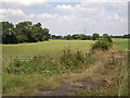
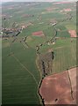
Gates and Pylons
The Beck, a small stream, flows through this shallow valley just beyond the trees on the left.
Image: © Michael Patterson
Taken: 28 Jul 2006
0.19 miles
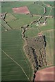
4
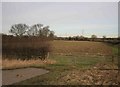
Gates and Pylons
Looking at the winter countryside through the gates from the A616 road.
Image: © roger geach
Taken: 1 Feb 2010
0.23 miles