IMAGES TAKEN NEAR TO
Hockerton Road, NEWARK, NG23 6BA
Introduction
This page details the photographs taken nearby to Hockerton Road, NG23 6BA by members of the Geograph project.
The Geograph project started in 2005 with the aim of publishing, organising and preserving representative images for every square kilometre of Great Britain, Ireland and the Isle of Man.

There are currently over 7.5m images from over14,400 individuals and you can help contribute to the project by visiting https://www.geograph.org.uk
Image Map
Images are licensed for reuse under creativecommons.org/licenses/by-sa/2.0
Notes
- Clicking on the map will re-center to the selected point.
- The higher the marker number, the further away the image location is from the centre of the postcode.
Image Listing (16 Images Found)
Images are licensed for reuse under creativecommons.org/licenses/by-sa/2.0
Image
Details
Distance
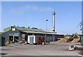
1
Park Springs
Caunton Grass Driers at Park Springs on Hockerton Road
Image: © Richard Croft
Taken: 24 Jul 2012
0.01 miles
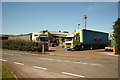
2
Bedmax factory
The company turns pine logs into bedding for horses.
Image: © Alan Murray-Rust
Taken: 24 Jul 2014
0.02 miles
3
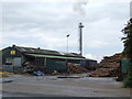
Woodchip factory
This plant converts the logs into shavings for use primarily as equestrian bedding, sold as Bedmax.
Image: © Jonathan Billinger
Taken: 29 May 2007
0.02 miles
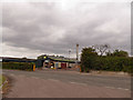
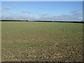
7
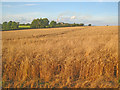
Wheat field near Park Leys
View north towards a smoking chimney at the Park Spring Farm grain drying plant.
Image: © Trevor Rickard
Taken: 20 Aug 2012
0.18 miles