IMAGES TAKEN NEAR TO
Maplebeck Road, NEWARK, NG23 6AS
Introduction
This page details the photographs taken nearby to Maplebeck Road, NG23 6AS by members of the Geograph project.
The Geograph project started in 2005 with the aim of publishing, organising and preserving representative images for every square kilometre of Great Britain, Ireland and the Isle of Man.

There are currently over 7.5m images from over14,400 individuals and you can help contribute to the project by visiting https://www.geograph.org.uk
Image Map
Images are licensed for reuse under creativecommons.org/licenses/by-sa/2.0
Notes
- Clicking on the map will re-center to the selected point.
- The higher the marker number, the further away the image location is from the centre of the postcode.
Image Listing (8 Images Found)
Images are licensed for reuse under creativecommons.org/licenses/by-sa/2.0
Image
Details
Distance
2
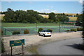
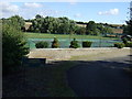
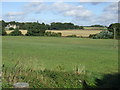
Caunton Lawn Tennis Club
View of the hard-courts at Caunton tennis club from Maplebeck Road
Image: © Richard Croft
Taken: 26 Jun 2011
0.03 miles
3
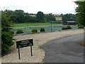
Caunton Lawn Tennis Club
Though no grass courts are visible in this photograph
Image: © Graham Hogg
Taken: 2 Aug 2016
0.04 miles
5
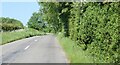
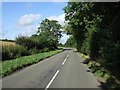
The Road to Maplebeck.
A quiet country lane.
Image: © steven ruffles
Taken: 27 May 2023
0.04 miles
7
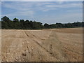
Footpath towards the A616 and Caunton
Path across a field of stubble east of Beesthorpe Hall.
Image: © Andrew Hill
Taken: 8 Sep 2012
0.16 miles
8
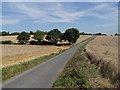
Lane from Beesthorpe Hall
Lane or driveway serving the hall and adjacent farm.
Image: © Andrew Hill
Taken: 8 Sep 2012
0.25 miles