IMAGES TAKEN NEAR TO
Mill View, NEWARK, NG23 5TF
Introduction
This page details the photographs taken nearby to Mill View, NG23 5TF by members of the Geograph project.
The Geograph project started in 2005 with the aim of publishing, organising and preserving representative images for every square kilometre of Great Britain, Ireland and the Isle of Man.

There are currently over 7.5m images from over14,400 individuals and you can help contribute to the project by visiting https://www.geograph.org.uk
Image Map
Images are licensed for reuse under creativecommons.org/licenses/by-sa/2.0
Notes
- Clicking on the map will re-center to the selected point.
- The higher the marker number, the further away the image location is from the centre of the postcode.
Image Listing (22 Images Found)
Images are licensed for reuse under creativecommons.org/licenses/by-sa/2.0
Image
Details
Distance
1
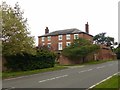
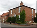
Upton Grange, Main Street, Upton
Originally a late 18th century house of 3 bays and 2 storeys, as indicated by the change in the brickwork, extended in the early 19th century by two more bays to the left, and an extra storey. Listed Grade II, the Listing includes the roadside wall.
Image: © Alan Murray-Rust
Taken: 23 Aug 2020
0.03 miles
2
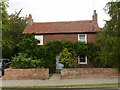
Wisteria Cottage, Main Street, Upton
More wisteria than cottage!
Early 19th century, c.1820, Listed Grade II.
Image: © Alan Murray-Rust
Taken: 23 Aug 2020
0.04 miles
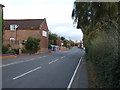
4
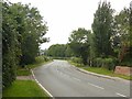
The exit from Upton
The A612 at the western end of the village, looking towards Southwell.
Image: © Alan Murray-Rust
Taken: 23 Aug 2020
0.10 miles
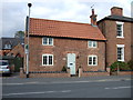
5
Crop House, Main Street, Upton
Early 19th century house, dated 1829, Listed Grade II.
Image: © Alan Murray-Rust
Taken: 23 Aug 2020
0.10 miles
7
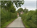
Mill Lane, Upton
Looking towards Main Street.
Image: © Alan Murray-Rust
Taken: 23 Aug 2020
0.12 miles
8
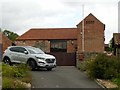
Former farm buildings at Dairy Farm
Barn with attached stable wing with dovecote, early 19th century, now converted to residential use, Listed Grade II.
Image: © Alan Murray-Rust
Taken: 23 Aug 2020
0.15 miles
9
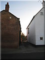
Narrow entrance
Two houses built close together with only a narrow entrance between. Main Street, Upton.
Image: © Jonathan Thacker
Taken: 13 Jan 2012
0.16 miles
10
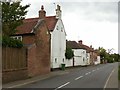
Main Street, Upton
Looking west near Dairy Farm.
There is a benchmark http://www.geograph.org.uk/photo/6579667 on the gable end of the nearest building.
Image: © Alan Murray-Rust
Taken: 23 Aug 2020
0.16 miles