IMAGES TAKEN NEAR TO
Fiskerton Road, NEWARK, NG23 5SJ
Introduction
This page details the photographs taken nearby to Fiskerton Road, NG23 5SJ by members of the Geograph project.
The Geograph project started in 2005 with the aim of publishing, organising and preserving representative images for every square kilometre of Great Britain, Ireland and the Isle of Man.

There are currently over 7.5m images from over14,400 individuals and you can help contribute to the project by visiting https://www.geograph.org.uk
Image Map
Images are licensed for reuse under creativecommons.org/licenses/by-sa/2.0
Notes
- Clicking on the map will re-center to the selected point.
- The higher the marker number, the further away the image location is from the centre of the postcode.
Image Listing (6 Images Found)
Images are licensed for reuse under creativecommons.org/licenses/by-sa/2.0
Image
Details
Distance
1
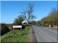
Fiskerton Road enters the village of Rolleston
Image: © Mat Fascione
Taken: 25 Mar 2016
0.11 miles
2
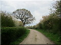
Swallow Lane
A road used as a public footpath.
Image: © Jonathan Thacker
Taken: 19 Apr 2022
0.16 miles
3
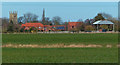
Farmland near the village of Rolleston
On the left is the tower of Holy Trinity church.
Image: © Mat Fascione
Taken: 25 Mar 2016
0.17 miles
4
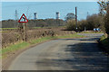
Fiskerton Road heading towards Rolleston
On the horizon are the chimneys of Staythorpe Power Station.
Image: © Mat Fascione
Taken: 25 Mar 2016
0.18 miles
5
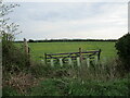
Gap in the hedge
Blocked with a gate and some new planting. A field full of celandines beyond.
Image: © Jonathan Thacker
Taken: 19 Apr 2022
0.23 miles
6
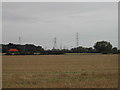
Pylons on the march
stretching forever across Rolleston Field
Image: © Tom Courtney
Taken: 7 Sep 2005
0.24 miles