IMAGES TAKEN NEAR TO
Kelham, NEWARK, NG23 5RX
Introduction
This page details the photographs taken nearby to NG23 5RX by members of the Geograph project.
The Geograph project started in 2005 with the aim of publishing, organising and preserving representative images for every square kilometre of Great Britain, Ireland and the Isle of Man.

There are currently over 7.5m images from over14,400 individuals and you can help contribute to the project by visiting https://www.geograph.org.uk
Image Map
Images are licensed for reuse under creativecommons.org/licenses/by-sa/2.0
Notes
- Clicking on the map will re-center to the selected point.
- The higher the marker number, the further away the image location is from the centre of the postcode.
Image Listing (5 Images Found)
Images are licensed for reuse under creativecommons.org/licenses/by-sa/2.0
Image
Details
Distance
3
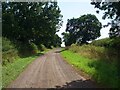
Track to Park Leys
Heading east towards the farm buildings and Muskham Wood.
Image: © Trevor Rickard
Taken: 20 Aug 2012
0.16 miles
4
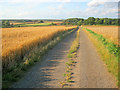
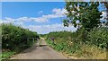
Farm track south of Park Leys
Heading north through the ripe corn fields to the farm buildings at Park Leys and Muskham Wood beyond. Oats on the left and wheat on the right.
Image: © Trevor Rickard
Taken: 20 Aug 2012
0.16 miles