IMAGES TAKEN NEAR TO
Averham, NEWARK, NG23 5RU
Introduction
This page details the photographs taken nearby to NG23 5RU by members of the Geograph project.
The Geograph project started in 2005 with the aim of publishing, organising and preserving representative images for every square kilometre of Great Britain, Ireland and the Isle of Man.

There are currently over 7.5m images from over14,400 individuals and you can help contribute to the project by visiting https://www.geograph.org.uk
Image Map
Images are licensed for reuse under creativecommons.org/licenses/by-sa/2.0
Notes
- Clicking on the map will re-center to the selected point.
- The higher the marker number, the further away the image location is from the centre of the postcode.
Image Listing (9 Images Found)
Images are licensed for reuse under creativecommons.org/licenses/by-sa/2.0
Image
Details
Distance
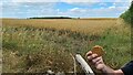
1
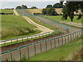
Racehorse gallops on the Trent Valley way
Image: © Andy Jamieson
Taken: 25 Aug 2008
0.03 miles
2
Equestrian centre
On the Trent valley way
Image: © Andy Jamieson
Taken: 25 Aug 2008
0.05 miles
3
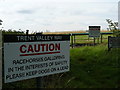
NOTICE NOTICE Notice!
The Gallops near Southwell
Image: © Andy Jamieson
Taken: 25 Aug 2008
0.07 miles
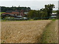
4
Averham Park
Part of the large equestrian training centre. See http://www.averhamparkracing.com. The signs caution walkers on the Trent Valley Way to look out for galloping racehorses
Image: © Tim Heaton
Taken: 30 Dec 2008
0.09 miles
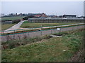
5
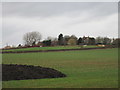
Averham Park
Home to a large equestrian centre.
Image: © Jonathan Thacker
Taken: 25 Feb 2017
0.14 miles
7
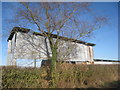
Corrugated iron shed
Used to store hay and straw. Associated with the Averham Park Equestrian Centre.
Image: © Jonathan Thacker
Taken: 7 Mar 2014
0.16 miles
8
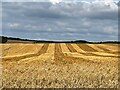
Stripes in the stubble
Not all of this field of oats has been harvested.
Image: © Graham Hogg
Taken: 23 Aug 2021
0.24 miles
9
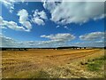
Blue sky above a field of stubble
An oat crop has been recently harvested.
Image: © Graham Hogg
Taken: 23 Aug 2021
0.25 miles