IMAGES TAKEN NEAR TO
Pingley Close, NEWARK, NG23 5RJ
Introduction
This page details the photographs taken nearby to Pingley Close, NG23 5RJ by members of the Geograph project.
The Geograph project started in 2005 with the aim of publishing, organising and preserving representative images for every square kilometre of Great Britain, Ireland and the Isle of Man.

There are currently over 7.5m images from over14,400 individuals and you can help contribute to the project by visiting https://www.geograph.org.uk
Image Map
Images are licensed for reuse under creativecommons.org/licenses/by-sa/2.0
Notes
- Clicking on the map will re-center to the selected point.
- The higher the marker number, the further away the image location is from the centre of the postcode.
Image Listing (9 Images Found)
Images are licensed for reuse under creativecommons.org/licenses/by-sa/2.0
Image
Details
Distance
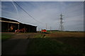
4
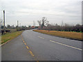
Staythorpe Road
Heading north-east towards the many pylons connecting the power lines to Staythorpe power station.
Image: © Trevor Rickard
Taken: 30 Jan 2012
0.11 miles
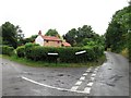
5
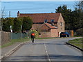
Cyclist passing Grange Farm
On Staythorpe Road in Staythorpe village.
Image: © Mat Fascione
Taken: 25 Mar 2016
0.14 miles
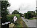
6
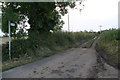
Track and footpath from Staythorpe to the River Trent
Image: © Chris
Taken: 19 Oct 2014
0.15 miles
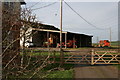
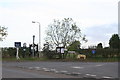
8
Farm buildings near Staythorpe
with power lines from the sub-station just south of here
Image: © Rick Hall
Taken: 31 Dec 2006
0.22 miles
9
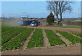
Farmland at Staythorpe
In the distance is the village of Upton.
Image: © Mat Fascione
Taken: 25 Mar 2016
0.22 miles