IMAGES TAKEN NEAR TO
Hughs Close, NEWARK, NG23 5RE
Introduction
This page details the photographs taken nearby to Hughs Close, NG23 5RE by members of the Geograph project.
The Geograph project started in 2005 with the aim of publishing, organising and preserving representative images for every square kilometre of Great Britain, Ireland and the Isle of Man.

There are currently over 7.5m images from over14,400 individuals and you can help contribute to the project by visiting https://www.geograph.org.uk
Image Map
Images are licensed for reuse under creativecommons.org/licenses/by-sa/2.0
Notes
- Clicking on the map will re-center to the selected point.
- The higher the marker number, the further away the image location is from the centre of the postcode.
Image Listing (27 Images Found)
Images are licensed for reuse under creativecommons.org/licenses/by-sa/2.0
Image
Details
Distance
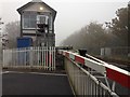
1
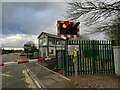
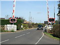
Staythorpe Level Crossing and Signal Box
Image: © Tom Courtney
Taken: 7 Sep 2005
0.01 miles
2
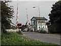
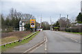
Tractor approaching the railway crossing
Staythorpe the view from near the railway crossing as a Tractor approaches.
Image: © roger geach
Taken: 10 Nov 2010
0.04 miles
4
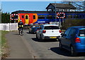
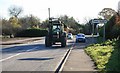
Level crossing in Staythorpe
The Nottingham to Lincoln railway line crossing Staythorpe Road.
Image: © Mat Fascione
Taken: 25 Mar 2016
0.05 miles
5
Staythorpe Crossing
On the Nottingham-Lincoln railway
Image: © Graham Hogg
Taken: 2 Nov 2015
0.05 miles
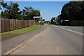
9
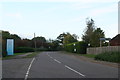
Staythorpe Level Crossing
On Staythorpe Road towards Rolleston.
Image: © Julian P Guffogg
Taken: 27 Jan 2016
0.06 miles