IMAGES TAKEN NEAR TO
Moor Lane, NEWARK, NG23 5PY
Introduction
This page details the photographs taken nearby to Moor Lane, NG23 5PY by members of the Geograph project.
The Geograph project started in 2005 with the aim of publishing, organising and preserving representative images for every square kilometre of Great Britain, Ireland and the Isle of Man.

There are currently over 7.5m images from over14,400 individuals and you can help contribute to the project by visiting https://www.geograph.org.uk
Image Map
Images are licensed for reuse under creativecommons.org/licenses/by-sa/2.0
Notes
- Clicking on the map will re-center to the selected point.
- The higher the marker number, the further away the image location is from the centre of the postcode.
Image Listing (8 Images Found)
Images are licensed for reuse under creativecommons.org/licenses/by-sa/2.0
Image
Details
Distance
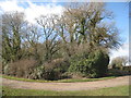
1
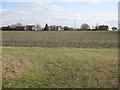
View towards Thorpe Lodge
Thorpe Lodge stands on a low rise in this gently undulating part of the country.
Image: © Jonathan Thacker
Taken: 25 Feb 2012
0.04 miles
2
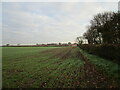
Autumn sown crop
Thorpe Lodge in the distance.
Image: © Jonathan Thacker
Taken: 26 Nov 2020
0.07 miles
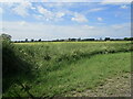
3
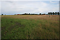
Farmland near Thorpe
Thorpe Lodge on the horizon.
Image: © Kate Jewell
Taken: 30 Sep 2006
0.09 miles
4
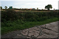
Private farm track, Honey's Lane.
This road leads to Thorpe Lodge although the farm on the horizon is Honies Farm in Image
Image: © Kate Jewell
Taken: 30 Sep 2006
0.17 miles
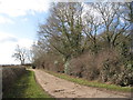
5
Bend in the lane
The significance of this bend is that to the left the road is private and to the right a public highway.
Image: © Jonathan Thacker
Taken: 25 Feb 2012
0.19 miles
6
Private road
It is just possible to see in the foreground of the picture where the tarmac of the public highway ends and the concrete of the private road begins.
Image: © Jonathan Thacker
Taken: 25 Feb 2012
0.19 miles
7
View across the Car Dyke towards Honies Farm
Image: © Jonathan Thacker
Taken: 29 Jun 2021
0.24 miles
8

Honies Farm
Looking across the fields from Moor Lane near the Car Dyke bridge.
Image: © Alan Murray-Rust
Taken: 10 Dec 2009
0.24 miles