IMAGES TAKEN NEAR TO
Chapel Farm Close, NEWARK, NG23 5PW
Introduction
This page details the photographs taken nearby to Chapel Farm Close, NG23 5PW by members of the Geograph project.
The Geograph project started in 2005 with the aim of publishing, organising and preserving representative images for every square kilometre of Great Britain, Ireland and the Isle of Man.

There are currently over 7.5m images from over14,400 individuals and you can help contribute to the project by visiting https://www.geograph.org.uk
Image Map
Images are licensed for reuse under creativecommons.org/licenses/by-sa/2.0
Notes
- Clicking on the map will re-center to the selected point.
- The higher the marker number, the further away the image location is from the centre of the postcode.
Image Listing (83 Images Found)
Images are licensed for reuse under creativecommons.org/licenses/by-sa/2.0
Image
Details
Distance
1
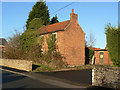
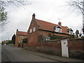
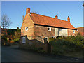
Chapel Farm
The farm buildings behind still appeared to be in use, but the farmhouse has seen better days.
Image: © Alan Murray-Rust
Taken: 10 Dec 2009
0.01 miles
2
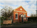
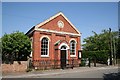
Methodist Chapel, Elston
Dates from 1871.
Image: © Jonathan Thacker
Taken: 26 Nov 2020
0.02 miles
3
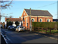
Elston Methodist Church
A typical mid-19th century non-conformist chapel.
Image: © Alan Murray-Rust
Taken: 10 Dec 2009
0.02 miles
4
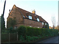
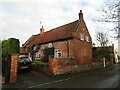
Berkeley Cottage
The roundel on the wall below the two dormer windows carries the initials and date
B
R H
1720
Image: © Alan Murray-Rust
Taken: 10 Dec 2009
0.03 miles
5
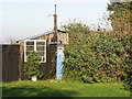
Old Village Petrol Pump, Elston
It almost looks like this old pump is playing "hide n seek"
Image: © Bob Danylec
Taken: 19 Nov 2005
0.04 miles
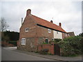
6
Ivy House, Elston
Has a stone (blue lias) base.
Image: © Jonathan Thacker
Taken: 26 Nov 2020
0.04 miles
7
Cottages on Low Street, Elston (2)
The nearer of these two cottages has a stone base but has been much altered. Nonetheless it retains many of the features of a vernacular cottage.
Image: © Jonathan Thacker
Taken: 1 Apr 2011
0.06 miles
9
Ardmore House
The name is a bit confusing as OS maps show Ardmore House on the opposite side of the street, although the name is clearly visible in this picture. The Listed Building details name it as Smith's House. It is in any case an early 17th century timber-framed building, with brick and stone cladding from the late 18th century. It was at one time a shop. Listed grade II.
Image: © Alan Murray-Rust
Taken: 10 Dec 2009
0.06 miles
10
Cottages on Low Street, Elston
Stone has been used in the lower courses. Some is Blue Lias but there is a lot of use made of Triassic sandstone.
Image: © Jonathan Thacker
Taken: 1 Apr 2011
0.07 miles