IMAGES TAKEN NEAR TO
Elston, NEWARK, NG23 5PP
Introduction
This page details the photographs taken nearby to NG23 5PP by members of the Geograph project.
The Geograph project started in 2005 with the aim of publishing, organising and preserving representative images for every square kilometre of Great Britain, Ireland and the Isle of Man.

There are currently over 7.5m images from over14,400 individuals and you can help contribute to the project by visiting https://www.geograph.org.uk
Image Map
Images are licensed for reuse under creativecommons.org/licenses/by-sa/2.0
Notes
- Clicking on the map will re-center to the selected point.
- The higher the marker number, the further away the image location is from the centre of the postcode.
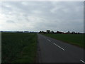
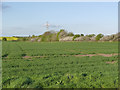
Image Listing (4 Images Found)
Images are licensed for reuse under creativecommons.org/licenses/by-sa/2.0
Image
Details
Distance
1
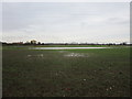
Waterlogged field
Much of the autumn sown cereal crop in this field is likely to be lost after recent persistent heavy rain.
Elston Grange on the left of the picture.
Image: © Jonathan Thacker
Taken: 22 Nov 2019
0.07 miles
4
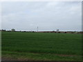
Landscape near Shelton
The hedgerow marks the line of Back Dike, which is also the boundary between Sibthorpe and Shelton parishes.
Image: © Alan Murray-Rust
Taken: 13 Apr 2014
0.21 miles