IMAGES TAKEN NEAR TO
Sibthorpe, NEWARK, NG23 5PN
Introduction
This page details the photographs taken nearby to NG23 5PN by members of the Geograph project.
The Geograph project started in 2005 with the aim of publishing, organising and preserving representative images for every square kilometre of Great Britain, Ireland and the Isle of Man.

There are currently over 7.5m images from over14,400 individuals and you can help contribute to the project by visiting https://www.geograph.org.uk
Image Map
Images are licensed for reuse under creativecommons.org/licenses/by-sa/2.0
Notes
- Clicking on the map will re-center to the selected point.
- The higher the marker number, the further away the image location is from the centre of the postcode.
Image Listing (44 Images Found)
Images are licensed for reuse under creativecommons.org/licenses/by-sa/2.0
Image
Details
Distance
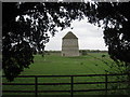
1
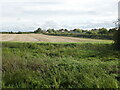
View from the churchyard, Sibthorpe
The uncultivated land in the foreground hides the site of a college of canons founded in 1341.
Image: © Jonathan Thacker
Taken: 25 Sep 2024
0.04 miles
2
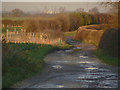
Baxter Lane
Byway leading from Top Green, Sibthorpe through to Breck's Lane.
Image: © Alan Murray-Rust
Taken: 10 Dec 2009
0.09 miles
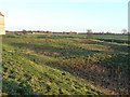
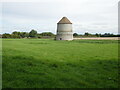
3
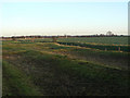
Landscape at Sibthorpe
In the foreground are the medieval fishponds, beyond which runs the Car Dyke, a significant tributary of the River Devon.
Image: © Alan Murray-Rust
Taken: 10 Dec 2009
0.10 miles
5
Sibthorpe dovecote seen between the churchyard yews
On a windy day the yews make a loud clattering.
Image: © Jonathan Thacker
Taken: 1 Apr 2011
0.12 miles
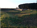
6
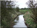
Medieval fishponds at Sibthorpe
They were part of a large collegiate complex which has almost entirely disappeared. There has apparently been some filling in in recent times, but they are currently used for grazing which means that the likelihood of damage is much reduced.
Image: © Alan Murray-Rust
Taken: 10 Dec 2009
0.12 miles
7
Medieval fishponds at Sibthorpe
They were part of a large collegiate complex which has almost entirely disappeared. There has apparently been some filling in in recent times, but they are currently used for grazing which means that the likelihood of damage is much reduced.
Image: © Alan Murray-Rust
Taken: 10 Dec 2009
0.13 miles
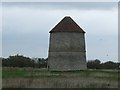
8
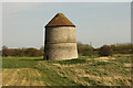
Sibthorpe Dovecote
Grade I listed 14th century pigeoncote with earthworks of medieval fishponds in the foreground
Image: © Richard Croft
Taken: 30 Mar 2021
0.13 miles
10
Sibthorpe Dovecote
Dates from the fourteenth century https://historicengland.org.uk/listing/the-list/list-entry/1243820?section=official-list-entry
Image: © Jonathan Thacker
Taken: 25 Sep 2024
0.13 miles