IMAGES TAKEN NEAR TO
Longhedge Lane, NEWARK, NG23 5NH
Introduction
This page details the photographs taken nearby to Longhedge Lane, NG23 5NH by members of the Geograph project.
The Geograph project started in 2005 with the aim of publishing, organising and preserving representative images for every square kilometre of Great Britain, Ireland and the Isle of Man.

There are currently over 7.5m images from over14,400 individuals and you can help contribute to the project by visiting https://www.geograph.org.uk
Image Map
Images are licensed for reuse under creativecommons.org/licenses/by-sa/2.0
Notes
- Clicking on the map will re-center to the selected point.
- The higher the marker number, the further away the image location is from the centre of the postcode.
Image Listing (8 Images Found)
Images are licensed for reuse under creativecommons.org/licenses/by-sa/2.0
Image
Details
Distance
1
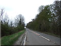
Longhedge Lane
An ancient thoroughfare leading to the River Trent
Image: © Richard Croft
Taken: 25 Apr 2007
0.06 miles
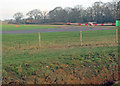
2
Syerston Reservoir
At the end of Longhedge Lane.
Image: © Alan Murray-Rust
Taken: 8 Dec 2009
0.10 miles
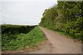
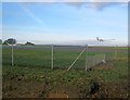
3
The end of Longhedge Lane
The lane used run down to the River Trent near Hazelford Ferry, but was cut when the wartime RAF Syerston was built.
Image: © Alan Murray-Rust
Taken: 8 Dec 2009
0.11 miles
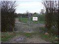
4
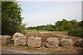
Syerston parkland
The remains of a concrete apron associated with RAF Syerston on the edge of Syerston Hall parkland
Image: © Richard Croft
Taken: 25 Apr 2007
0.19 miles
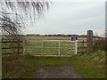
5
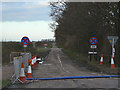
Longhedge Lane
This is the road section looking north west from the A46. It leads to what were originally the ancillary buildings of Syerston Hall, and although always a dead end, was truncated by the construction of Syerston airfield.
Image: © Alan Murray-Rust
Taken: 6 Dec 2009
0.22 miles
6
Light aircraft taxiing at Syerston Aerodrome
Looking north from the old A46 to the corner of the airfield.
Image: © Trevor Rickard
Taken: 28 Jan 2012
0.23 miles
7
Aircraft landing at Syerston Airfield
About to touch down as others wait to take off.
Image: © Trevor Rickard
Taken: 28 Jan 2012
0.24 miles