IMAGES TAKEN NEAR TO
Town End Lane, NEWARK, NG23 5LT
Introduction
This page details the photographs taken nearby to Town End Lane, NG23 5LT by members of the Geograph project.
The Geograph project started in 2005 with the aim of publishing, organising and preserving representative images for every square kilometre of Great Britain, Ireland and the Isle of Man.

There are currently over 7.5m images from over14,400 individuals and you can help contribute to the project by visiting https://www.geograph.org.uk
Image Map
Images are licensed for reuse under creativecommons.org/licenses/by-sa/2.0
Notes
- Clicking on the map will re-center to the selected point.
- The higher the marker number, the further away the image location is from the centre of the postcode.
Image Listing (8 Images Found)
Images are licensed for reuse under creativecommons.org/licenses/by-sa/2.0
Image
Details
Distance
3
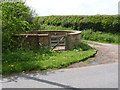
Flintham pinfold
Early 19th century circular pinfold, restored 1977 to mark the Silver Jubilee of Queen Elizabeth II. Listed Grade II.
Image: © Alan Murray-Rust
Taken: 27 Apr 2014
0.06 miles
4
Flintham Pinfold
Restored in 1977, on Town End Lane by the track to Beck Dyke
Image: © Richard Croft
Taken: 25 Apr 2007
0.07 miles
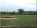
5
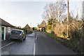
Town End Lane, Flintham
Entering Flintham.
Image: © Julian P Guffogg
Taken: 4 Feb 2017
0.18 miles
6
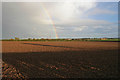
Rainbow over Hill Top Farm
Brilliant late afternoon sunshine during a heavy shower brings out the rich colour of the soil in this field and is low enough to create a rainbow.
Image: © Kate Jewell
Taken: 21 Oct 2006
0.21 miles
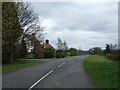
7
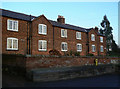
High Bank
An unusual pair of dwellings, probably built for estate workers, at the eastern end of the village.
Image: © Alan Murray-Rust
Taken: 10 Dec 2009
0.22 miles
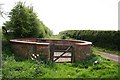
8
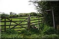
Footpath to Hawksworth
Stile on Town End Lane
Image: © Richard Croft
Taken: 25 Apr 2007
0.22 miles