IMAGES TAKEN NEAR TO
Station Road, NEWARK, NG23 5JY
Introduction
This page details the photographs taken nearby to Station Road, NG23 5JY by members of the Geograph project.
The Geograph project started in 2005 with the aim of publishing, organising and preserving representative images for every square kilometre of Great Britain, Ireland and the Isle of Man.

There are currently over 7.5m images from over14,400 individuals and you can help contribute to the project by visiting https://www.geograph.org.uk
Image Map
Images are licensed for reuse under creativecommons.org/licenses/by-sa/2.0
Notes
- Clicking on the map will re-center to the selected point.
- The higher the marker number, the further away the image location is from the centre of the postcode.
Image Listing (12 Images Found)
Images are licensed for reuse under creativecommons.org/licenses/by-sa/2.0
Image
Details
Distance
1
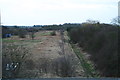
Bridge over disused railway by Cotham station
The course of the Bottesford to Newark line of the Great Northern Railway. Opened in 1878, closed to passengers in 1939 and to all traffic in 1988.
Image: © Chris
Taken: 12 Feb 2014
0.01 miles
2
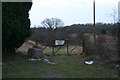
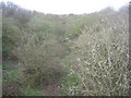
Land next to the disused railway trackbed at former Cotham Station
The course of the Bottesford to Newark line of the Great Northern Railway. Opened in 1878, closed to passengers in 1939 and to all traffic in 1988.
Image: © Chris
Taken: 12 Feb 2014
0.05 miles
3
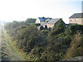
Station House
This is the site of the old Cotham Station on the now disused Newark to Bottesford railway. Image
Image: © Bob Danylec
Taken: 20 Nov 2005
0.05 miles
4
Looking southwards down the disused railway trackbed at the site of Cotham Station
The course of the Bottesford to Newark line of the Great Northern Railway. Opened in 1878, closed to passengers in 1939 and to all traffic in 1988.
Image: © Chris
Taken: 12 Feb 2014
0.11 miles
5
There once was a railway
The course of the Bottesford to Newark line of the Great Northern Railway. Opened in 1878, closed to passengers in 1939 and to all traffic in 1988.
Image: © Jonathan Thacker
Taken: 1 Apr 2011
0.11 miles
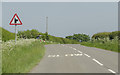
6
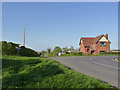
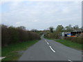
Road junction near Cotham
These particular roads are remarkably anonymous on maps, and don't link to any specific villages.
Image: © Alan Murray-Rust
Taken: 13 Apr 2014
0.19 miles
8
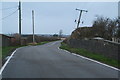
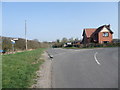
Sharp bend in the road
Near Station Farm. The road is unnamed.
Image: © J.Hannan-Briggs
Taken: 5 Jun 2016
0.19 miles
9
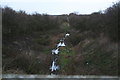
Looking towards Cotham along the disused railway trackbed from Cotham Station
View from the bridge. Lots of puddles. It's the wettest and windiest winter for about 200 years, the Thames has burst its banks and the Somerset Levels have been under water for two months.
The Bottesford to Newark line of the Great Northern Railway was opened in 1878, closed to passengers in 1939 and to all traffic in 1988.
Image: © Chris
Taken: 12 Feb 2014
0.20 miles