IMAGES TAKEN NEAR TO
The Lane, NEWARK, NG23 5JT
Introduction
This page details the photographs taken nearby to The Lane, NG23 5JT by members of the Geograph project.
The Geograph project started in 2005 with the aim of publishing, organising and preserving representative images for every square kilometre of Great Britain, Ireland and the Isle of Man.

There are currently over 7.5m images from over14,400 individuals and you can help contribute to the project by visiting https://www.geograph.org.uk
Image Map
Images are licensed for reuse under creativecommons.org/licenses/by-sa/2.0
Notes
- Clicking on the map will re-center to the selected point.
- The higher the marker number, the further away the image location is from the centre of the postcode.
Image Listing (38 Images Found)
Images are licensed for reuse under creativecommons.org/licenses/by-sa/2.0
Image
Details
Distance
2
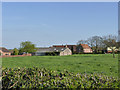
The Old Hall Farm, Cotham
Much of the farmyard has been redeveloped as housing.
Image: © Alan Murray-Rust
Taken: 13 Apr 2014
0.07 miles
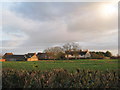
4
Cotham
Cotham village entry from the south
Image: © Richard Croft
Taken: 28 May 2012
0.14 miles
5
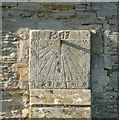
Sundial, St Michael's Church, Cotham
Not quite the right time, as the markings require the sundial to be facing due south, and the church is not quite on a true east-west alignment.
Image: © Alan Murray-Rust
Taken: 13 Apr 2014
0.16 miles
6
Churchyard gates
Rusting gates to St.Michael's church
Image: © Richard Croft
Taken: 4 Jun 2008
0.16 miles
7
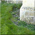
Bench mark, St Michael's Church, Cotham
See http://www.geograph.org.uk/photo/3936091 for location.
Image: © Alan Murray-Rust
Taken: 13 Apr 2014
0.16 miles
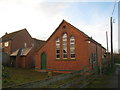
8
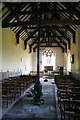
St.Michael's nave
Redundant but immaculately maintained, the box pews have been replaced by chairs and a pot-bellied stove and flue provide the only heating
Image: © Richard Croft
Taken: 4 Jun 2008
0.16 miles
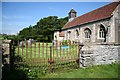
9
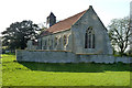
St Michael's Church, Cotham
This is now in the care of the Churches Conservation Trust http://www.visitchurches.org.uk/ .
The church today is much smaller than in medieval times, the changes probably dating from the 18th century. It now consists just of this simple nave. Listed Grade II*.
The churchyard wall and gate are also listed, Grade II for group value. Access to the church is simply by walking through the field in the foreground.
There is a bench mark http://www.geograph.org.uk/photo/3936088 on the nearest buttress of the gable.
Image: © Alan Murray-Rust
Taken: 13 Apr 2014
0.16 miles
10
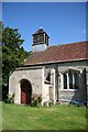
St.Michael's porch
Georgian porch of 1830 and neat bellcote of 1890 at St.Michael's church
Image: © Richard Croft
Taken: 4 Jun 2008
0.16 miles